2.1 Tectonic movements of the earth's crust
The movements of the earth's crust, as a result of which the high-altitude position of the surface and its constituent rocks change, the conditions and forms of occurrence, the formation of new relief forms is called tectonic. Geodetic measurements show that the entire surface of the Earth is in continuous tectonic movement. These movements are caused by forces that act in the crust and mainly in the mantle. They lead to deformations of the rocks composing the crust, transgression and regression of the sea, raising some areas of the earth's crust and lowering others, located next to them.
Seismic phenomena appear in the earth's crust, folding is formed, magmatism at depth and volcanism occur on the surface. There are tectonics of past geological eras and modern - Quaternary (neotectonics).
Tectonic movements are diverse in the form of manifestation, in the depth of origin, in the mechanism and causes of occurrence.
Tectonic movements are divided into vertical (radial) and horizontal (tangential). They are mutually connected and transfer one type to another.
Vertical, oscillatory movements in the manifestation and change of direction lead to a change in the outlines of coastlines, basins, lakes, change the direction of geological activity, which leads to attenuation or renewal of such exogenous processes and phenomena as the formation of terraces, flooding of river mouths, undermining, gullying, violation dynamic equilibrium relief, the accumulation of thick layers of Quaternary sediments or their deep erosion.
Tangential movements lead to mountain building, the appearance of folded (plicative) and discontinuous (disjunctive) dislocations, the manifestation of magmatism, volcanism and seismic.
Mountain-building processes occurred throughout the formation of the lithosphere. Dislocations are associated with them - violations of the primary bedding. There are plicative and disjunctive dislocations.
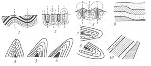
Plicative (folded) dislocations are a change in the position of a layer without breaking its continuity. Forms of plicative dislocations: monocline, flexure, folds (Figure 8). Depending on the position of the axes of the folds, the folds are straight, oblique, oblique, recumbent, etc.
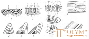
Figure 8 - Types of folds:
1 - full (normal); 2 - isoclinic; 3 - chest;
4 - straight; 5 - slanting; 6 - inclined; 7 - recumbent; 8 - overturned;
9 - flexure; 10 - monoclinic;
Elements of the folds (Figure 9).
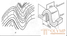
Figure 9 - Full fold (a) and fold elements (b):
1 - anticline; 2 - syncline
Disjunctive (discontinuous) dislocations. At the beginning, the layer breaks, and then one part shifts relative to the other. Types of rupture dislocations (Figure 10).
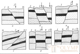
Figure 10 - Discontinuous dislocations:
a - reset; b - step reset; in - a flip; d - thrust; d - graben; e - horst; 1 - the fixed part of the sequence; 2 - the displaced part; P - the surface of the Earth; p - plane of rupture of layers
When building in the areas of development of dislocations, it should be borne in mind that in the cores of the folds of the rock are heavily crumpled, in the arches - high fracturing. When monoclinal occurrence in the base can be rocks of different strength and compressibility. In fracture zones with discontinuous dislocations, rocks are crushed and, over time, weathering processes penetrate to a greater depth through them, besides these zones accumulate precipitation and form aquifers.
2.2 Seismic phenomena
Earthquakes
The powerful manifestation of the internal forces of the Earth, expressed by the oscillations of the earth's surface during the passage of seismic waves from an underground energy source, is called an earthquake. There are three types of seismic waves:
- Longitudinal waves. They compress and stretch the rock, creating tension in it in the direction of wave propagation. They pass at the speed of sound through solid and liquid media.
- Transverse waves - shear particles of matter to the sides at a right angle to the direction of the wave at a speed of about 4.5 km / s. They are distributed only in solid media.
- Surface waves have a period of oscillation longer than longitudinal and transverse waves. They are called waves of gravity.
For capturing and recording elastic waves use special devices - seismographs (Figure 11)
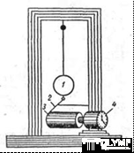
Figure 11 - Seismograph with a vertical pendulum:
1 - pendulum; 2 - writing lever; 3 - drum with paper;
4 - hours
The source of seismic waves is called the hypocenter (Figure 12).
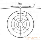
Figure 12 - Hypocenter (G), epicenter (Sn) and seismic waves:
1 - longitudinal; 2 - transverse; 3 - surface
The region of the Earth, where suddenly, potential energy is explosively released, is called the hypocenter, and its projection onto the Earth's surface is the epicenter. The region of greatest destruction is located around the epicenter - the pleistoseist region The lines connecting the points with the same intensity of vibrations (in points) are called isoseistists (Figure 13).
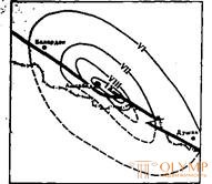
Figure 14 - Isoseist scheme of the Ashgabat Gorshkov earthquake (1948).
The distance between the hypocenter and the epicenter is the depth of the seismic source. By the depth of the seismic source, earthquakes are divided into surface (up to 10 km), normal (10-75 km), deep (75300 km) and very deep (300-700 km).
The hypocenter may shift in depth when earthquakes repeat.
The hypocenter is called the center as an earthquake point purely arbitrary, since it is most often a fracture along a crack and the magnitude and inclination of such a crack are different depending on the breaking energy.
From the hypocenter, the waves, gradually fading, diverge by distances of up to several thousand kilometers. The distribution range depends largely on the geological structure of the area. In mountainous areas, the waves attenuate much faster than on the plain. During the Ashgabat earthquake of 1948, the shock waves spread in the direction of the West Siberian Plain to 2500 km.
The speed of propagation of seismic waves depends on the elasticity and density of the rock. Moving from a more dense elastic medium to a less dense and elastic or vice versa, seismic waves experience reflection and refraction, which is recorded on a seismogram and allows you to designate the boundaries of layers of rocks of different composition, density, humidity, and then, using standards, build a geological section.
Depending on the causes of earthquakes, they are divided into endogenous (tectonic), exogenous (landslide), volcanic and anthropogenic, associated with human activity - explosions, underground tests, accidents at large hydroelectric power stations, etc. The most dangerous are tectonic, since their energy released during an earthquake is very significant.
Earthquake strength is estimated on the scales of magnitudes (M) and points of magnitude (J).
On the magnitude scale, known as the Richter scale, the magnitude of any earthquake is defined as the decimal logarithm of the maximum amplitude of a seismic wave (expressed in microns) recorded by a standard seismograph at a distance of 100 km. from the epicenter.
Known maximum magnitudes M = 8.5 -9. Magnitude is a calculated value, a relative characteristic of a seismic focus, used to estimate the total energy released in the focus (a functional relationship between magnitude and energy is established).
The magnitude of the largest earthquakes corresponds to the release of energy 1017-1018 J.
The intensity of the manifestation of earthquakes on the surface of the earth (the shakiness of the surface) is determined by the scales of seismic intensity and is estimated in arbitrary units - points. In Russia, as in most countries of the world, the 12-point International seismic scale MSK-64 is used.
In the textbook V.P. Ananeva, A.D. Potapova (2006) provides a formula for calculating a ball:
The ball (J) is a function of the magnitude (M), the depth of the source
(h) and the distance from the point under consideration to the epicenter (L).
The magnitude is determined by the seismogram. When assessing the destructive impact of a seismic wave, the angle at which it comes from the hypocenter to the surface of the Earth is of great importance. The resulting seismic wave decomposes into two components - normal and horizontal (Figure 14). At the epicenter, the structure will experience only vertical shocks. The greatest damage occurs under the action of the horizontal component of the seismic wave, which should be considered when assessing the destructiveness of an earthquake.
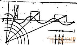
Figure 14 - Earthquake mechanism:
G - hypocenter; E - epicenter; 1 - the vertical component of the seismic wave; 2 - the horizontal component of the seismic wave; I - oscillations of particles with longitudinal; II - oscillations of particles at transverse waves.
For the entire territory of the country, depending on the geological structure and tectonics, areas of seismic hazard of different magnitudes are identified. These areas are confined to the mountain systems: Crimea, Central Asia, the Far East, Kamchatka, Sakhalin, Mongolia, and others. The seismic map shows areas and zones, for each of which the potential seismic hazard is indicated in points from 6 to 9. It is set for average geological conditions that may be different. Therefore, microseismonioning is introduced in the areas under protection in seismically dangerous areas. The intensity of earthquakes in the points indicated on the seismic zoning map, in this case, can be adjusted by ± (1-2) points depending on local tectonic conditions, geomorphology, soil and hydrogeological conditions, as well as on the type of structures.
Construction in seismically hazardous areas is carried out taking into account the requirements of building codes and regulations approved for these areas. It should be borne in mind that during earthquakes, large mudflows are possible, the occurrence of seismic landslides and landslides, the phenomena of liquefaction of fine-grained and fine-grained water-saturated sands, their transition to a floating state.
When earthquakes occur on the seabed (seaquake), giant waves are formed, which, falling on the shore, cause great damage.
Earthquake intensity scale (with abbreviations )
Intensity, score | Earthquake summary |
I | Imperceptible earthquakes. Shaking of the soil is detected and recorded only by instruments. |
II | Imperceptible earthquakes. Fluctuations are felt only by individuals. |
III | Mild concussion. In buildings, swaying of hanging objects is observed, sometimes the rattling of dishes is heard. Earthquake is felt by many people. |
IY | A noticeable earthquake. Fluctuations in the soil are similar to vibrations caused by a heavily loaded truck passing by. The houses can hear the rattling of glass, dishes, creaking doors, floors, walls. |
Y | Awakening. An earthquake is felt by all people, sleeping ones are waking up, animals are worried. Hanging objects are swinging heavily, and unstable tipping over. Small cracks appear in buildings, whitewashing and plastering is peeling off. |
Yi | Scare People who are in buildings get scared and run out into the street, animals leave their shelters. Furniture is shifting from its seats. Cracks up to 1 cm wide appear in wet soils. |
Yii | Damage to buildings. People have difficulty keeping their feet. There are cases of destruction of buildings made of natural stone (clay and torn bricks), cracks appear on the roads, and pipeline joints are broken. There are isolated cases of landslides in the mountains and on the banks of rivers, seas. |
YIII | Severe damage to buildings. Fright and panic, break off tree branches. Many buildings are destroyed from natural stone. Numerous cracks appear in stone houses, plaster is showered. Monuments and statues |
are shifting. Cracks in the ground reach several centimeters.
General damage to buildings. General panic. Selected cases of destruction of brick buildings. Bend railway
IX paths. Cracks in the ground reach 10 cm in width. Waves form on the surface of water bodies, floods occur on the plains.
Total destruction of buildings. Brick buildings are destroyed, serious damage occurs in dams, dams, bridges. Road
asphalt coatings acquire a wave
X white surface. Cracks in the ground reach 1 m. On the banks of rivers, seas, mountain slopes there are large landslides. There are cases of splashing water in lakes, canals, rivers.
Catastrophe. Reinforced concrete buildings are damaged. Bridges, dams, railway
XI ways of life. Smooth surface becomes wavy. The width of cracks and soils reaches 1 m. Along the fractures, vertical and horizontal movements of rocks occur. There are landslides and landslides in the mountains. Relief changes. Severe damage or destruction of almost all land and underground structures. Cracks in the ground
XII are accompanied by significant vertical and horizontal movements. The relief changes due to numerous landslides, landslides, displacements. There are lakes and waterfalls, changing the direction of the river beds.
2.3 Global Earth tectonics (plate tectonics)
There are quite a few scientifically-based assumptions (tectonic hypotheses) about the causes of movement and deformation of the earth's crust, creating its structures. However, questions about the causes of tectonic deformations still can not be considered finally resolved. The hypothesis of the “new global tectonics” proposed in the 60s – 70s of the 20th century by X. Hess, R. Didom and others is most popular. The new global tectonics assumes the existence of subcortical convection currents and is based on the data of paleomagnetism and the results of sea bottom drilling . According to the "new global tectonics", a relatively "fragile" lithosphere, underlain by the plastic asthenosphere, is divided into rigid plates separated from each other by tectonic breaks. Plates include continents and parts of the oceans and experience a spreading (spreading) with respect to each other to form rift zones, and then oceans; a feat (subduction) with immersion of one plate under another (Figure 15,16) or transform faults are formed. This is a long-acting right or left-side shifts. In the process of creation or destruction of the crust are not involved. Here, shear and discontinuous dislocations prevail. In our country, the questions of the “new global tectonics” were developed by academicians V. Ye.
Hein, P.I. Kropotkin, A.V. Peive et al.
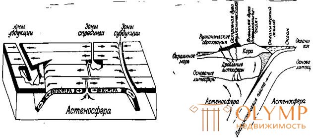
Figure 15 - Block diagram showing the dynamics of nucleation (spreading) and absorption
(subduction) of the lithosphere
Figure 16 - Scheme of subduction of the ocean floor
At present, seven large plates are distinguished in the upper shell of the Earth: Pacific, Eurasian, Indo-Australian, Antarctic, African, North- and South American (Figure 17). Within large plates, medium and small plates or blocks are distinguished. All plates move relative to each other, so their boundaries are clearly marked with zones of high seismicity.
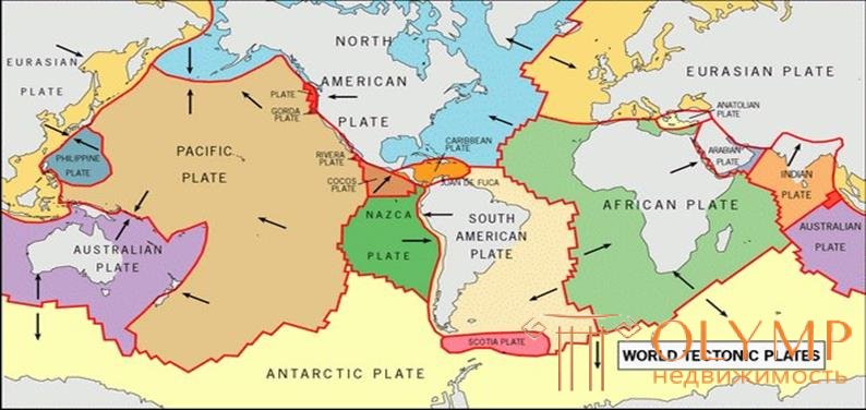
Figure 17 - Plate layout
Что бы оставить комментарий войдите
Комментарии (0)