17.1. Summer shooting
Typically, aerial photography is performed on a smaller scale than the specified scale of the map or plan being fabricated.
Aerial photography is performed so that the longitudinal overlap is at least 60%, and the transverse at least 40%.
To ensure a given amount of overlap, it is necessary to observe the basis of photographing. The basis of photography is the distance that an airplane flies between two adjacent photographing points. The basis of photographing is calculated by the formulas:
 ,
,
 ,
,
Where
 - longitudinal basis of photographing along the route;
 - the distance between the axes of two adjacent routes;
 - dimensions of the longitudinal and transverse sides of the aerial photograph;
 - the denominator of the scale of aerial photography.
To facilitate the driving of the aircraft and its approach from the route to the route, the landmarks are clearly visible on the map in advance.
After performing aerial photography, the recorded cassettes are processed, and aerial photographs are made from the negatives obtained after the development and fixation of the negatives by contact printing.
To check the summer surveys, a box-mounted installation is performed, which is an approximate connection of aerial photographs along their contours of the same name into one complete picture of the recorded area.
The quality assessment of the shooting survey is carried out according to the following criteria:
1) the quality of the photographic image;
2) the size of the longitudinal and transverse overlap;
3) avoidance of the camera axis from the vertical;
4) straightness of the route;
5) evasion of a given altitude of the aircraft.
The identified shortcomings of aerial photography are eliminated. Captive photograph photographed on a small scale - get a reproduction of a cap assembly. It is used for a preliminary study of the area.
The aerial photograph of the horizontal section of the flat terrain obtained with the plumb position of the AFA optical axis is an outline plan of this terrain suitable for various measurements.
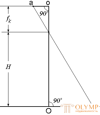
Fig. 100. The scale of the horizontal aerial photograph
The scale of such an aerial photograph (Fig. 100) is called horizontal, expressed by the ratio
 ,
,
Game: Perform tasks and rest cool.2 people play!
Play gameIf the optical axis deviates from the vertical position, then the resulting aerial photograph will have a different scale at each of its points. In this case, you can only talk about the average scale of the image.
17.3. The offset point in the picture due to the relief.
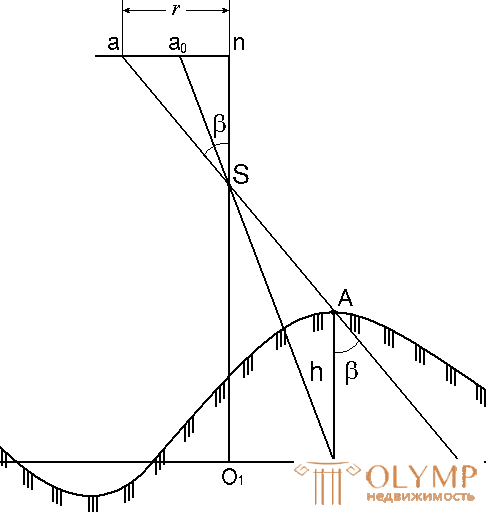
Fig. 101. Offset image point on the aerial photograph due to terrain
The projection of the vertical passing through the axis of the lens is called the nadir point and is denoted by n (Fig. 101). This is the most undistorted point in the image. Point A is displayed in the picture at a distance r from point n, i.e. an = r .
If point A were in the plane of the middle level surface, then it would be represented at the point a0. Consequently, the segment a0a represents the displacement of point a, caused by the influence of the terrain relief. This offset is called the offset point for terrain and is denoted by  .
.
Directly from Fig. 101 is obtained
 ,
,
Where
h is the elevation of the terrain point over the median plane;
r is the distance from the main point of the image to the point where the correction for the relief should be entered;
H - height of the flight of the aircraft.
17.4. Transformation of aerial photographs
Due to the influence of the inclination angles during aerial photography and the influence of the terrain relief, the image on the aerial photograph does not correspond to the plan and therefore the task of transforming the aerial photograph arises.
Transformation is the transformation of the central projection, which is an aerial photograph obtained with an oblique projection of the main beam, into another central projection corresponding to its vertical position, while simultaneously bringing the image to a predetermined scale.
The most common method of transformation with the help of special optical devices - phototransformers . It consists of a projection lamp with a light source, a lens, a cassette and a screen onto which a transformable image is projected. The phototransformer allows you to eliminate the distortion of aerial photographs by moving and tilting the cassette and the screen until the four orienting points of the aero-negative coincide with those of the reference tablet of the same name. If after this, instead of a tablet, you put photo paper on the screen and retake the negative, then you get a transformed picture.
After the transformation of the working areas make up a terrain plan, which is called a photo plan.
On photoplanes, the entire contour part is a photographically reduced image of objects and contours of the area. Photoplan more accurately reproduces the situation of the area than the topographic map.
To transform images, you must have four points with known coordinates on them. These points can be obtained with field-based snapshots, but then the volume and cost of work increase significantly. Therefore, under field conditions, a discharged reference is made, at which the coordinates of two to three points per route are determined, and the planned position of the four transformation points of each image is obtained under office conditions.
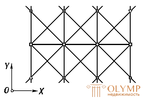
The process of thickening the planned position of the points can be performed by building special networks of phototriangulation or photopolygonometry, the points of which are determined analytically on electronic computers, as well as by graphical construction.
Phototriangulation is based on the inherent property with small tilt angles of the property, which consists in the fact that the central angles with the apex at the main point of the image or near this point are almost equal to the corresponding horizontal angles on the ground. Phototriangulation can be developed analytically by measuring the central angles or coordinates of points on the photographs, or graphically using waxes of the directions to which the corners are transferred from the photographs.
17.6. Interpretation of aerial photographs
Recognition of photographic objects of the terrain and the identification of their content with the image of qualitative and quantitative characteristics by conventional signs is called decryption.
Deciphering is the most important, responsible and very labor-intensive process in studying the terrain and phenomena from aerial photographs.
The quality of information obtained from photographs largely depends on the accuracy of determining the position on the photographic image of the decrypted elements of the terrain, the reliability and completeness of their characteristics.
Depending on the content, the interpretation is divided into topographical and special.
When topographic interpretation of aerial photographs receive information about the earth's surface and terrain elements for the preparation of topographic maps and plans.
With special interpretation, thematic information is selected (geological, geobotanical, railway track elements, etc.).
Interpretation is also divided into field, cameral and combined.
Field interpretation consists in comparing the aerial photograph with the terrain. This method ensures the highest completeness of the quality and reliability of the interpretation results. However, field interpretation requires a significant investment of time and money.
The cameral method of interpretation consists in the analysis of the photographic image of terrain objects using the whole complex of signs of interpretation. At the same time, albums of decoding standards are used.
The combined method combines the process of office and field interpretation. Undoubtedly recognizable objects of the terrain are decrypted in the cameral conditions, then the field completion of complex areas is carried out.
17.7. Creating topographic maps from aerial photographs
Topographic maps for aerial photographs are created using a combination of stereoscopic methods.
In the combined method, the contour part of the plan is created using aerial photographs in cameral conditions, and the relief is taken in the field using a scale sheet.
The relief survey is carried out on photo plans, photo patterns and on individual photographs. Pre-created high-rise shooting justification, for which determined the height of the planned reference signs or clear contours. In parallel with the shooting of the relief can be performed interpretation.
A photo plan (photo or single image) is attached to the tablet and the heights of the characteristic points of the relief are determined by trigonometric leveling. With flat terrain leveling perform a horizontal beam.
Photograph helps to select characteristic points. In addition, on the well-visible points of the area, the slats are not installed, and the angles of inclination are measured by pointing the center directly to the points.
Game: Perform tasks and rest cool.2 people play!
Play gameShooting relief on photoplanes takes two times less time than with a conventional scale survey.
With the stereo-photometric method ah, relief drawing is performed in the office. Stereoscopic terrain model is obtained on special stereo instruments: measuring stereoscopes, stereocomparators, universal stereophotogrammetric instruments, monocomparators, etc., as well as on a computer monitor screen.
There are two ways of stereoscopic relief drawing: universal and differentiated.
With the universal method, using spatial overlapping images on stereophotogrammetric instruments, a spatial model of the terrain is created, which is used to determine the X, Y, Z coordinates of any point of the terrain. As a result of measurements on the stereo model with the universal method, horizontals are automatically drawn on paper. For this purpose, stereographs or topographic stereographs are used.
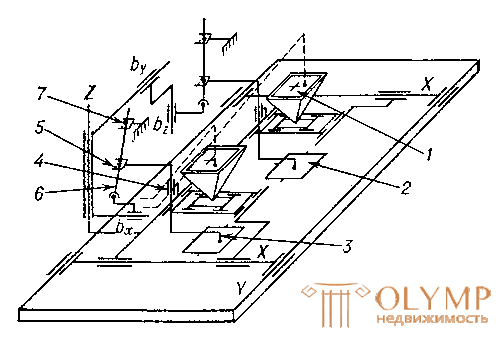
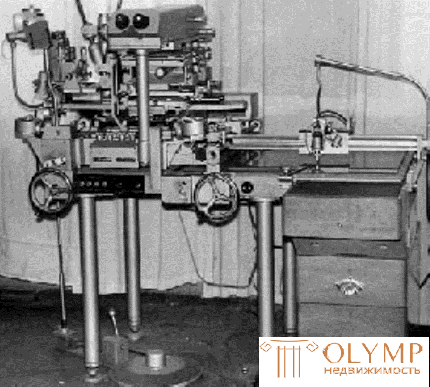
Stereograph
In the differentiated method, a single process of creating a plan or a map of the area is divided into a number of stages. The heights of the relief points are received by the office, by measurements on the stereo model, after that they draw horizontals in the pictures, using the resulting heights, as in the field survey.
Recently, digitizers, converters of graphic information into digital, have become widely used.
17.8. Questions for self-control
1. What are the types of photo topographical surveys?
2. What is aerial photography?
3. How does an aerial photograph differ from a map?
4. How to determine the scale of the aerial photograph?
5. What is aerial photo transformation?
6. What is aerial photo interpretation?
7. What are the methods of creating topographic maps for aerial photographs?
Что бы оставить комментарий войдите
Комментарии (0)