16.1. Photogrammetry and its purpose
Photogrammetry (from the Greek. Photos - light, gramma - record, metreo - measurement) is the science of determining the quantitative and qualitative characteristics of the images.
There are the following types of photogrammetric surveys:
1. Ground photography;
2. Aerial photography;
3. Space photography.
Ground-based photography is mainly used to create maps of mountain areas, quarries. At the same time special devices are used - phototheodolites, which are mounted on a tripod and therefore they are called phototheodolites.
Aerial photography is widely used to create topographic maps and plans of various scales (1: 500 - 1: 100 000). Aerial photography allows to significantly increase labor productivity and economic efficiency of topographic and geodetic production and engineering - geodetic surveys.
16.2. Aerial photography
Aerial photography is a set of flight survey, photographic and photogrammetric works, as a result of which aero-negatives and aerial photographs of the terrain are obtained.
In aerial photography, various aircraft are used: airplanes, helicopters, hang gliders, etc.
Depending on the position of the optical axis of the aerial camera in space, there are distinguished planned and perspective photographing.
Planned photography is such a photograph, in which the optical axis of the camera departs from the plumb line by no more than 3 °. If this deviation exceeds 3 °, then such aerial photography is called perspective or oblique.
In topographic aerial photography, the main type of photographing is planned.
Aerial photography is divided into single, route and areal.
A single is called aerial photography in which get one or more shots.
Itinerary is called aerial photography of the terrain strip from one approach of the aircraft. In this case, aerial photographs mutually overlap in the direction of flight.
Aerial is called aerial photography of a large area of the earth's surface by laying several straight and mutually parallel routes. In this case, aerial photographs of neighboring routes overlap (Fig.96).
The overlap of aerial photographs in the direction of the shooting route is called longitudinal and is denoted by the letter p .
The overlap of aerial photographs of adjacent routes is called transverse and is denoted by the letter q .
Game: Perform tasks and rest cool.2 people play!
Play game
Fig. 96. Longitudinal and transverse overlap
The magnitude of the overlap is expressed as a percentage relative to the size of the corresponding side of the aerial photograph.
Longitudinal and transverse overlaps are necessary for the connection of aerial photographs into the overall system during their photogrammetric processing.
16.3. Aerial survey equipment
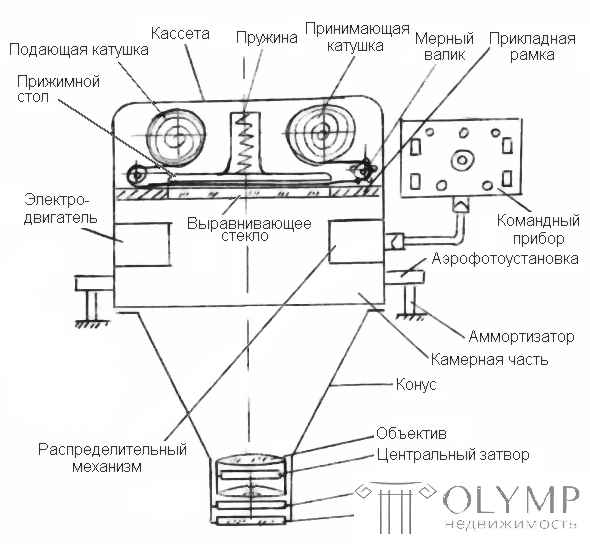
During aerial photography, images of the area are obtained with aerial cameras (AFA), the circuit diagram of which is as follows (Fig.97):
Game: Perform tasks and rest cool.2 people play!
Play game
Fig. 97. Aerial camera
The lens of the camera must give a sharp and geometrically correct image. Modern aerial cameras are full automatic. They produce a series of aerial photographs after a specified period of time, while the magnitude of the exposure automatically changes due to different lighting conditions of the terrain, automatic rewinding of the aerofilm, its alignment, etc.
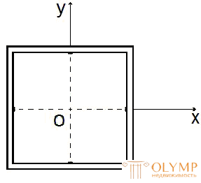
In addition to the AFA, during aerial photography, auxiliary devices are used, which allow to determine how the aerial photographs were oriented in space at the time of the shooting. These devices include a statoscope and a radio altimeter . The plane into which the aerial film is aligned and the image of the terrain is created is called the plane of the applied frame (Fig. 98) or the focal plane of the aerial camera.
Coordinate marks are applied to the alignment glass that define the coordinate system of each image, the image of which is fixed on the aerial photograph. The size of the application frame determines the format of the aerial photograph.

Fig. 98. APA application frame
In aerial photography, in order to map the terrain, aerial cameras with an aspect ratio of 18 × 18 or 30 × 30 cm are used.
16.4. Aerial view and map. Their difference and similarity
The aerial view is theoretically and practically sharply different from the map, for example, in appearance. At the same time, the map and the aerial photograph have much in common, since both of these documents are images of the terrain. This image both on the map and on the aerial photograph was obtained at a certain scale, which is characterized by the size of the images of various topographic objects.
The essential difference of the aerial photograph from the topographic map stems from the geometric essence of their receipt.
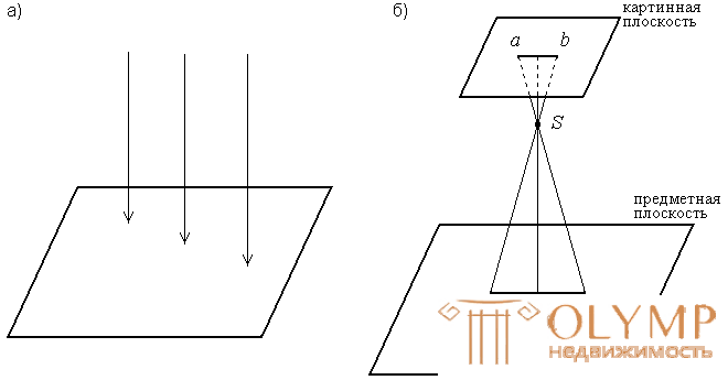
Topographic map - orthogonal projection of the terrain (Fig. 99, a), i.e. such a projection, in which the image of terrain objects on a plane is obtained with the help of projection rays perpendicular to the projection plane.

Fig. 99. Projection: a) orthogonal; b) central
Orthogonal projection is characterized by two main properties: the distances on the map are proportional to the horizontal distance of the corresponding distances on the ground; corners with vertices at any point of the map are equal to the corresponding horizontal angles on the terrain.
In contrast to the map on aerial photographs, the image of terrain objects is constructed by projecting rays intersecting in the lens of the aerial camera.
The projection in which the image of objects on the plane is obtained with the help of projecting rays intersecting at one point is called central (Fig. 99 b), and the intersection point of these rays is the center of projection. Consequently, the image of the aerial photograph is a central projection of the terrain.
Что бы оставить комментарий войдите
Комментарии (0)