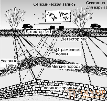
Geophysics is an applied science in which the capabilities of physics and mathematics are used to study the earth. To study the bowels of the earth, geophysicists, usually versed in mathematics and physics, use three surface methods: gravitational, magnetic and seismic. Most of the funds allocated for research are spent on seismic exploration, where the most advanced technologies are used.
Gravimetric exploration is a method of exploratory geophysics based on the study of the Earth's gravitational field. The main condition for the applicability of gravimetric reconnaissance is the presence of a difference in the density of rocks composing geological structures that can create anomalies in the observed gravitational field of the Earth.
The method of exploratory geophysics, based on the study of the gravitational field of the Earth.
The method of exploratory geophysics, based on the study of the gravitational field of the Earth.
The main condition for the applicability of Gravimetric exploration is the presence of a difference in the density of rocks composing geological structures that can create anomalies in the observed gravitational field of the Earth.
Gravimetric exploration identifies structures hidden by sedimentary rocks and therefore inaccessible to study by conventional geological methods. As a result of gravimetric surveys according to qualitative estimates of the gravitational field, both perspective areas for prospecting for minerals (total geological production) and individual geological structures in which oil, gas and various ore deposits can be distinguished can be distinguished.
With detailed gravimetric reconnaissance, local anomalies of gravity are carefully studied in order to determine the conditions and elements of the occurrence of anomaly-forming objects (depth, shape and size).
In the general case, the solution to this problem is ambiguous: you can pick up an infinite number of different distributions of anomalous masses that create the same gravitational anomaly.
An unambiguous solution can be found by making certain assumptions about anomalous masses and using geological information and conclusions of other geophysical methods. Geological surveys, as a rule, are conducted in conjunction with magnetic exploration, electrical exploration and seismic exploration.
Along with the observed gravitational anomalies in gravimetric reconnaissance, various derivatives derived from them or the same gravitational anomalies, but corresponding to points above and below the earth's surface, are often used.
The conversion operation is called the transformation of the gravitational field.
By the qualitative nature of the transformed gravitational field, separate geological structures are better distinguished. Under favorable conditions, transformation allows you to determine their depth and shape.
To solve the problems of gravimetric reconnaissance, a gravimetric survey is carried out, which, according to the conditions of its production, is divided into land, sea (surface, underwater, bottom), underground and air.
The data of gravimetric surveys are used to study the deep structure of the Earth.
Gravimeters and magnetometers are portable devices, relatively inexpensive, simple to use. The gravimeter is used to measure the acceleration of gravity at a specific point on the earth's surface. The magnetometer is designed to measure the magnetic field of the Earth at a specific point on the surface. Both of these devices are quite small in size, and they can be transported in the back of a pickup truck. A magnetometer can be used to measure using an aircraft - such studies are called aeromagnetic imaging, as well as attaching it to the stern of the vessel. The gravimeter can not be used either from the air or in the ocean due to the vibrations arising there.
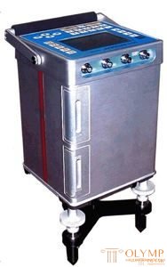
(Portable automatic gravimeter)
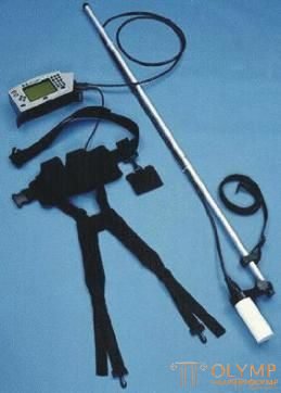
(portable magnetometer)
The gravimeter is very sensitive to changes in the density of underground rocks. It determines the acceleration of gravity in milligals. In the case where the site of the earth's crust does not have anomalies and consists of a layer of sedimentary rocks more than 5000 feet thick. (1500 m), underlain by bedrock, the result of measurements of the gravimeter is predictable (see, Fig. 1).
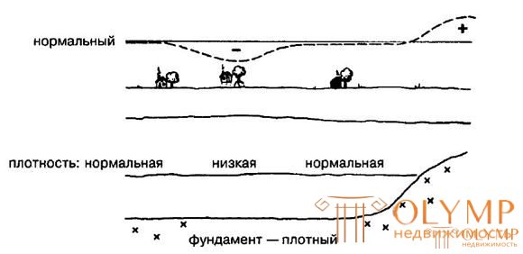
(Fig. 1 Gravimetric measurements of the territory)
The thickness of relatively light rocks, such as a salt dome or a porous reef, can be detected with a gravimeter using lower than average gravity. Accordingly, the presence of a layer of relatively heavy rocks located close to the surface, for example, foundation rocks in the center of the dome or anticline, can be determined by higher than average gravity.
A magnetometer measures the strength of the Earth’s magnetic field in units called gausses and nano-units. He subtly feels the presence of rocks containing magnetite with him - a highly magnetic mineral. If a mass of magnetite-containing rocks (i.e., basement rocks) is located close to the surface, it can be detected by the presence of a magnetic field strength exceeding the average value in a given area (see Fig. 2).
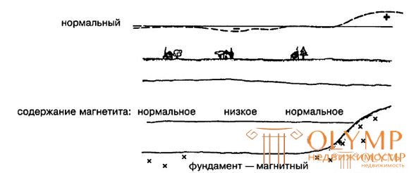
(Fig. 2 Magnetometric measurements in the territory)
The magnetometer can be used to determine the depth of the rocks and their composition, assess the thickness of sedimentary rocks of the basin, as well as determine the location of discharges displacing the foundation rock.
To explore the bowels with a gravimeter, a grid of key points is placed on this site. In each, the gravimeter reads, then the values are applied to the main map and isolines are drawn in the same way as on the topographic map. In an aeromagnetic survey, an airplane flies around two systems of parallel lines intersecting at right angles. According to magnetic field measurements, contours can also be drawn. In most of the territory, gravity and magnetic field will be “normal”. The task is to identify areas with gravitational or magnetic anomalies.
The presence of an underground salt dome can be determined by ground-based anomalies of relatively low gravity and low magnetic field strength, since the salt has a relatively low density and does not contain magnetite crystals, in contrast to the surrounding sedimentary rocks (see Fig. 3).
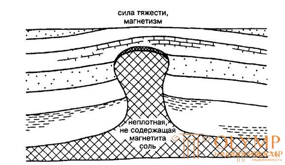
(Fig. 3 Gravity and magnetic anomalies above the salt dome)
It was using gravimetric surveys along the coastal territories of Texas and Louisiana that numerous salt domes were discovered.
Underground reefs can also be characterized by gravitational anomalies in the direction of both increase and decrease. Higher values are observed in dense (non-collector type) limestone reefs, lower values in porous reefs. Magnetic measurements are not usually used to locate reefs. The location of the dome or anticline can be identified by high values of both gravity and magnetic field. This is due to the presence of a dense magnetite-containing foundation located close to the surface at the center of the structure (see Fig. 4).
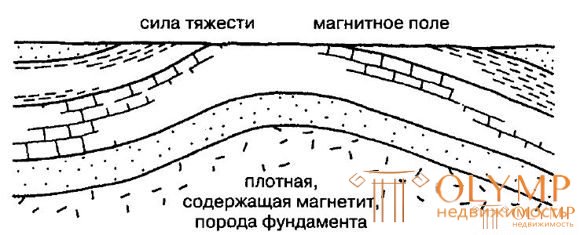
(Fig. 4 Gravity and magnetic anomalies above a dome or anticline)
Gavar, the world's largest natural oil field, was discovered in 1948 in Saudi Arabia using gravimetric surveys. The surface was covered with sand dunes, but an extensive anomaly of increased gravity was observed.
An underground discharge with a downward displacement can lead to a sharp jump along the discharge line of values of both gravity and magnetic field, since the foundation rock on one side of the discharge lies higher than on the other (see Fig. 5).
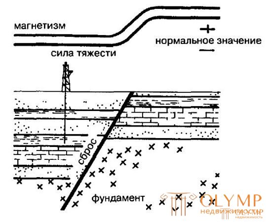
(Fig. 5 Gravity and magnetic anomalies above the discharge)
Minor changes at shallow depths and strong at large give the same values of gravitational and magnetic anomalies. Because of this, it is difficult to determine the size of the structure and its depth by anomaly.
Literature:
1. Norman J. Hein. Geology, exploration, drilling and oil production. M .: CJSC Olymp-Business, 2008 - 752 p.
Prepared by: Legkovsky A.A.
Что бы оставить комментарий войдите
Комментарии (0)