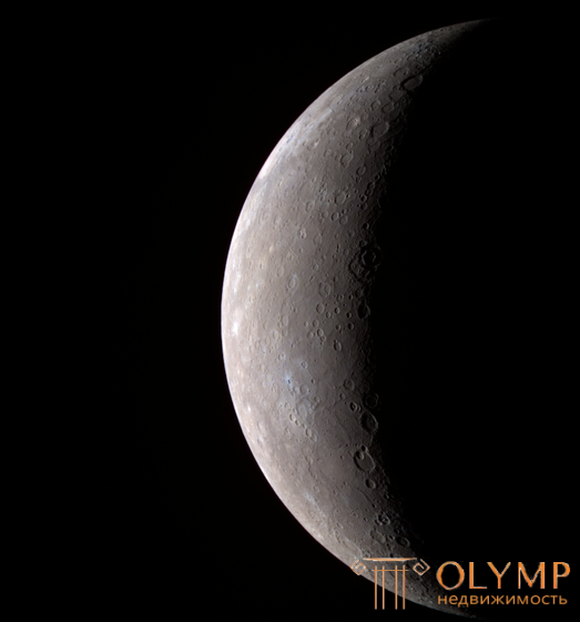
With the development of space technology, more and more will be used to study planets, first automatic stations, and then vehicles that deliver researchers to the surface of planets. It is also possible to create intermediate ones. bases and permanent: research stations on some planets and asteroids. All this makes us study the soils covering the nearest celestial bodies from the point of view of their composition, structure and properties.

It is now clear to us that the formation of soils on other planets does not always follow the terrestrial type. This is determined by other physical conditions of the surface of all space neighbors closest to us. In some cases, there is no air envelope on them, in others it is insignificant, and in others it turns out to be more powerful than on our planet. The composition of the gas shells, their temperature and the nature of their movement also differ. The situation with the hydrosphere is even more complicated. In liquid form, besides the Earth, it most likely also exists in the Martian crust, and in the form of ice, vaporous, and possibly liquid substances, it is found in the atmosphere of Venus and other planets (for example, Jupiter and its satellites).
All these factors lead to special conditions for the formation of soils on the surrounding celestial bodies. Even igneous rocks pouring out from the bowels of the planets often have a specific structure and composition that distinguishes them from earthly ones. Planets such as Mercury, Mars, as well as the Earth's satellite - the Moon, and asteroids are bombarded by meteorites, giving rise to special conditions for the formation of their soils.
So far there are only the first data on the nature of soils in space, but they also testify to their great diversity.
All the considered features of our satellite allow us to assume that the following genetic types of soils are found on it * igneous rocks; volcanic ash; meteorite formations formed due to meteorites and the processes occurring during their fall; cosmic dust; loose soils that have arisen during physical (thermal) weathering during a sharp change in daytime and nighttime temperatures.
The existing experience in the operation of automatic stations, samples delivered to Earth and information from American astronauts who landed on the lunar surface suggest the presence of the following groups of soils in the lunar crust:
1) rocky, composed of basalts (their variety is regolith), the samples of which were delivered to Earth. Their feature is a significant amount of titanium-containing minerals. It also uses the distribution of gabbro (its variety is dolerite);
2) coarse-grained, which include stones and debris ranging in size from several meters to 2–20 mm;
3) sandy-silty, forming layers from centimeters to many tens of meters thick.
Lunar rocks are classified into three groups:
Game: Perform tasks and rest cool.9 people play!
Play gameANT rocks (anorthosite — norite — troctolite) are rocks dominated by plagioclases and pyroxenes, with olivine impurities. Age 3.6-4.6 billion years, usually the oldest rocks. They are products of meteorite fall and metamorphism, have undergone intense structural changes that almost completely destroyed their primary features. Most ANT rocks are breccias and can be composed of a mixture of rocks that have formed independently [2].
Game: Perform tasks and rest cool.7 people play!
Play gameRocks containing compounds of potassium - K and rare earth elements (eng.Rare earth element) - REE and phosphorus - P.
Today on Earth there are samples of lunar rock that came to Earth from the following sources:
Regolith (from ancient Greek ῥῆγος - blanket and ancient Greek λίθος - stone) - residual soil, which is a product of space weathering of rocks in place [3].
Currently, this term is most often called the surface layer of loose lunar soil .
Non-layered, loose, uneven-grained clastic-dusty layer reaching a thickness of several tens of meters. It consists of fragments of igneous rocks, minerals, glass, meteorites and breccias of shock-explosive origin, cemented by glass [7].
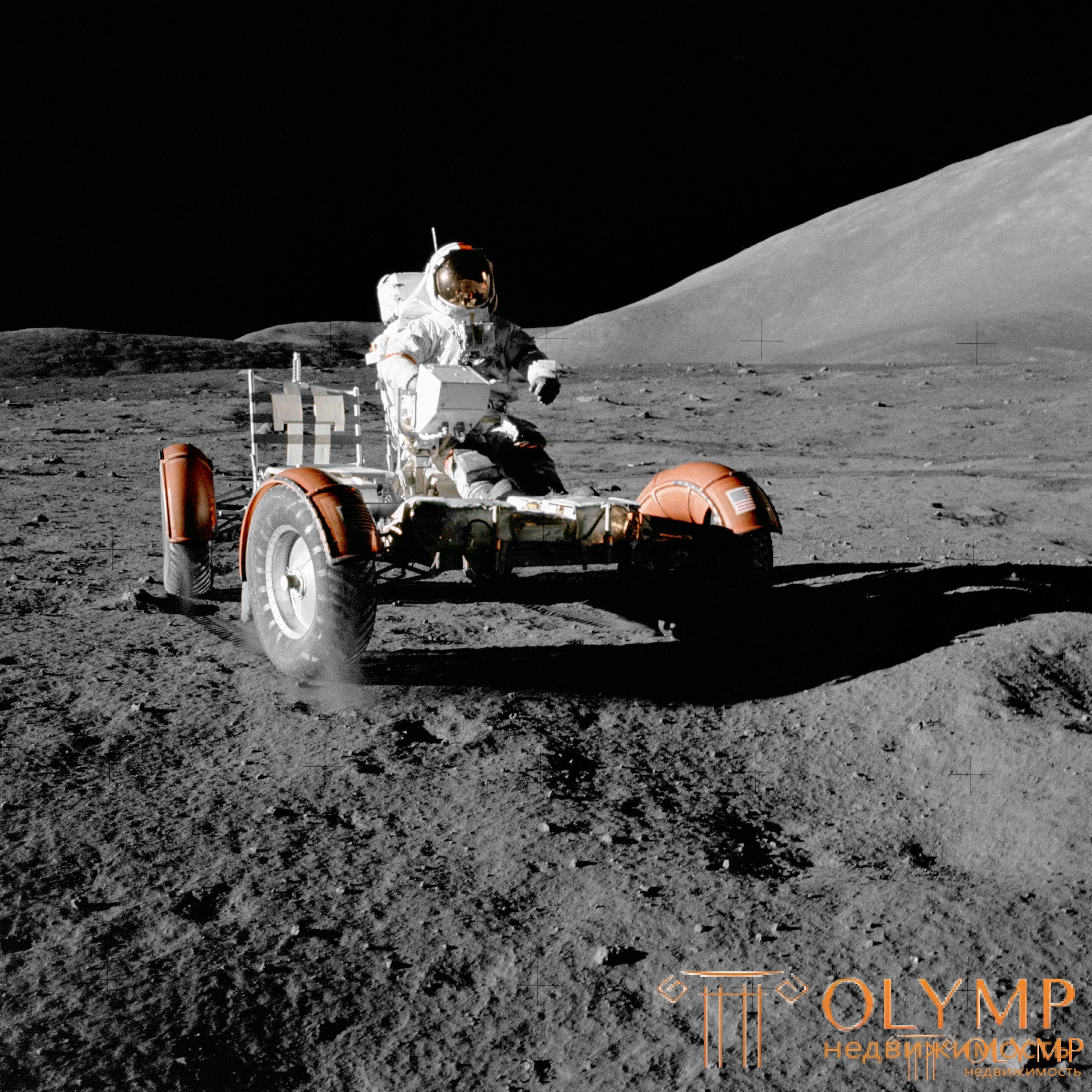
In terms of its granulometric composition, it belongs to silty sands (the bulk of the particles have a size of 0.03-1 mm). The color is dark gray, up to black, with inclusions of large particles with a mirror shine. Soil particles have high adhesion due to the absence of an oxide film on their surface and high electrification. In addition, lunar dust easily rises upward from impacts and adheres well to the surface of solids, which caused a lot of inconvenience to the members of the Apollo expeditions. According to Armstrong, Aldrin and Professor VF Scott [8], the regolith has a characteristic smell of burning and shot pistons in the earth's atmosphere.
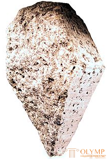
Rice Lunar anorthosite.
The conditions for the formation of lunar soils differ significantly from those of the earth. First of all, there is no air envelope, so the surface either heats up under the influence of sunlight to 80-130 ° C, then quickly cools down to minus 100-150 ° C at the onset of a moonlit night.
A.P. Vinogradov distinguishes two types of particles in the regolith: angular, similar to freshly crushed rock, and the predominant rounded particles with traces of fusion and sintering. Many of them are vitrified and look like glass and metal drops. According to the mineral composition of the regolith, it was established that the lunar seas are composed mainly of basalts, and among the rocks of the continents, anorthosites and their varieties prevail. Regolith of both types is characterized by the presence of metallic iron particles.
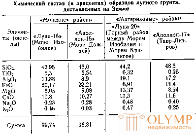
The results of laboratory analyzes of lunar soil samples delivered to Earth have shown that, being delivered even from one region of the Moon, they have noticeable differences in their composition. However, despite this, as well as the more significant difference in the composition of individual fragments of the same sample, a number of samples most typical for this region can be distinguished, having a very similar chemical composition, to which the composition of most other samples of this region is similar.
Table 3
Composition of the main rocks of the lunar regolith
| Name | Class | Formula |
|---|---|---|
| Ilmenite | Titanium iron ore | FeTiO3 |
| Olivine | Iron-magnesium silicate | (Mg, Fe) 2 [SiO4] |
| Anorthite | Calcium aluminosilicate | Ca [Al2Si2O8] |
| Pyroxene | Alkaline silicates | R2 [Si2O6], where R is Na, Ca |
Elemental composition of lunar regolith (in%)
| Element | Marine regolith | Mainland regolith | Regolith of individual basins |
|---|---|---|---|
| Ca | 7.9 | 10.7 | 7,7 |
| Mg | 5.8 | 4.6 | 6.1 |
| Fe | 13.2 | 4.9 | 3.7 |
| Al | 6.8 | 13.3 | 9.8 |
| Ti | 3.1 | 0 | 0 |
| Si | 20.4 | 21.0 | 21.8 |
| O | 41.3 | 44.6 | 43.3 |
| S | 0.1 | 0.072 | 0.076 |
| K | 0.1 | 0.073 | 0.24 |
| Na | 0.3 | 0.48 |
0.38
|
The moon has on its surface such rather rare geological formations as caves
In 2015, scientists published an article on the discovery of a new type of lunar soil - basalts of unusual composition with the help of Yuytu [38]. Samples of this soil differ from everything that was collected by American astronauts in 1969-1972 during the Apollo program and the Soviet stations Luna-16, Luna-20, Luna-24
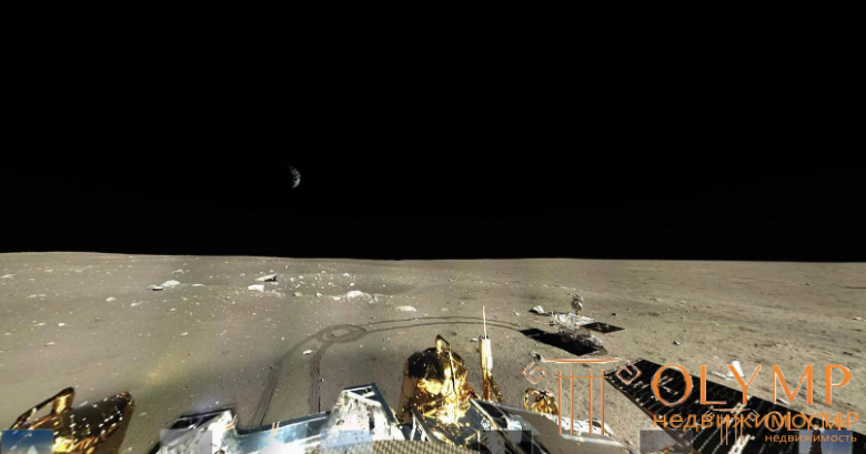
Rice Panorama of the Moon. 2014 The Chinese lunar rover Yuytu is visible on the right, and the Earth to the left and above
In August - September 1975, two spacecraft, Viking-1 and -2, were launched in the United States towards Mars one after the other. Having reached Mars after about 11 months, they entered the orbit of artificial satellites. Descent vehicles were delivered from the orbital modules of the spacecraft to the surface of Mars at different points on its surface, at a distance of about 6500 km from each other.
Among a number of experiments carried out by these devices (which also included an experiment to detect organic life on Mars, which, unfortunately, has not yet yielded unambiguously interpretable results), was an experiment to determine the chemical composition of the surface layer of the Martian soil by X-ray fluorescence analysis. The instrument for this experiment was a further development of X-ray spectrometric equipment intended for space experiments.
Martian soil was poured into a special chamber (Fig. 13) with a volume of a little more than 4 cm3 with the help of a miniature excavator blade. Two radioactive sources placed side by side irradiated the soil through the chamber windows; the response fluorescent radiation of the ground passed through the same windows, which was recorded by four detectors. Filters were used to determine the contribution of elements with similar radiation energies (as in the experiments described above).
Game: Perform tasks and rest cool.9 people play!
Play game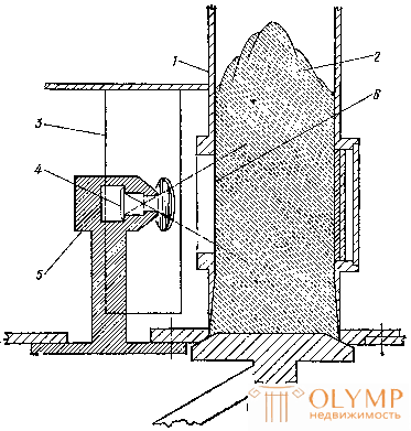
Figure: 13. Scheme of the experiment on the study of the chemical composition of the surface of Mars using the "Viking" spacecraft: 1 - chamber into which the soil sample was filled; 2 - soil sample; 3 - proportional counter; 4 - radioactive source (cadmium-109); 5 - source collimator and protective shield; 6 - a thin film window in the chamber through which the analysis was carried out
The results were very interesting. Comparison with the chemical composition of terrestrial and lunar rocks showed that the spectrum of the Martian soil (Fig. 14) does not coincide with any of the spectra obtained in ground-based experiments. So, for example, the Martian soil contains little aluminum, potassium and titanium, but it is relatively rich in iron and very rich in sulfur (see Table 4).
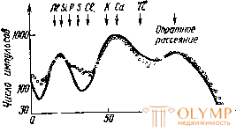
Figure: 14. Spectrum of fluorescent radiation of the surface of Mars at the landing site of the descent vehicle "Viking-1". For comparison, the spectrum, which is the closest in character, obtained during ground tests, is shown (solid line). The significant sulfur content in the Martian soil is striking
Table 4
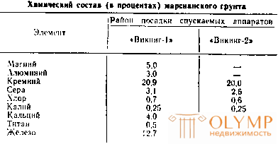
To what extent the results obtained reflect the general picture of the content of elements in the surface layer of Mars, it is still difficult to say, since the analysis was carried out only at two points of the planet's surface. However, the first thing that catches the eye when comparing the chemical composition of both landing areas of the Viking descent vehicles is that the composition of all studied soil samples turned out to be practically the same, although the soil for analysis was taken at very distant points from each other, from different depths and in the form of grains of different sizes.
The relatively high iron content on Mars confirms the existing opinion that the red color of the surface of this planet owes its origin to the presence of iron oxides there. It is possible that they can cover the outside of grains of other minerals, but this coating should be thin or discontinuous.
Sulfur broke all records: its content in the soil of Mars turned out to be one or two orders of magnitude higher than in terrestrial and lunar rocks. The reason for this anomaly is not yet clear, just as it is unclear, for example, and in the form of what compounds sulfur can enter into the minerals that make up the surface of Mars.
The low potassium content in the Martian soil is also characteristic. It is at least 5–8 times less than in the earth's crust. The ratio of calcium to potassium concentrations, which is on the order of 10 (and possibly even higher), indicates that the surface of Mars is not composed of granites (as is typical for the Earth).
Strontium, yttrium and zirconium are found in the surface layer of Mars (about 0.01% for each element). Their number turned out to be less than in terrestrial volcanic rocks.
|
|
|
|
Zobor of the first test on October 7, 2012. |
|
|
MARSOE CURIOSITY |
|
|
|
|
|
MARSOE CURIOSITY |
|
|
|
|
The site near the "Rocknest" dark rock cluster was chosen as the site for sampling the first sand and Martian dust samples for chemical analysis using a rover scoop. Mosaic compiled from photos taken with the right eye of the MastCam on Sol 52 (September 28, 2012), four days before arriving at "Rocknest". The Rocknest cluster covers an area of 1.5 meters by 5 meters.
|
Game: Perform tasks and rest cool.13 people play!
Play game
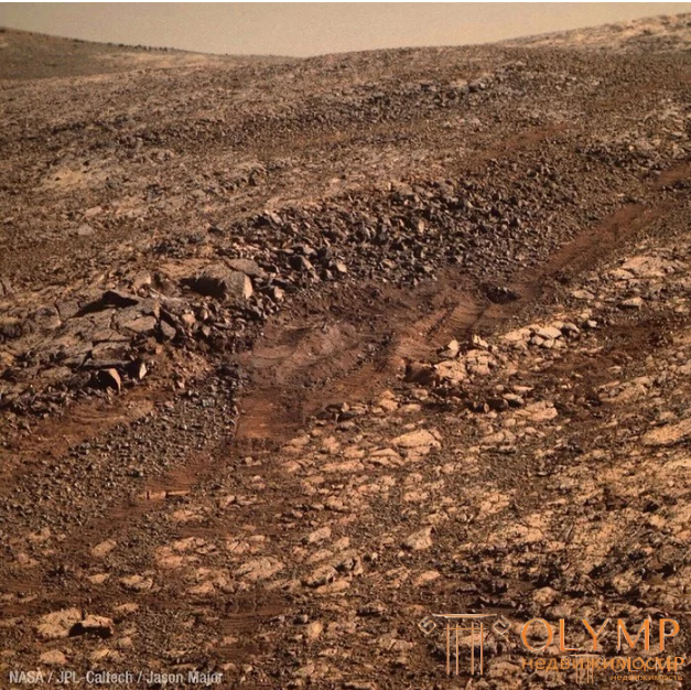
Rice Martian soil. Opportunity snapshot dated November 15, 2017.
Venus has long been a mystery to astronomers. The fact is that Venus is surrounded by a powerful atmosphere. It contains several layers of clouds from an altitude of 18 to 75 km, covering the surface of the planet.
Venus closely resembles Earth in size, density, and gravity. The Venusian year is about 225 days, but the length of the day is 118 Earth days. Interestingly, Venus has no magnetic field.
Soviet stations "Venera-9, -10, -11 and -12", helped to reveal the mystery that shrouded the planet. First of all, it was found that there is always a sizzling heat here. The surface temperature is about 500 ° C. The lower near-planetary air layer consists of carbon dioxide, the density of which is 70 times higher than that of the surface layer. The pressure of the atmosphere on the surface of Venus reaches 9.8 MPa.
The conditions for the formation of soil properties are quite peculiar here. The temperature is almost always the same. The difference between its daytime and evening values is less than 1 ° С. There is no rain, because there is very little water in the planet's atmosphere. Be * ter is relatively weak and hardly exceeds the speed of 1 m / s. However, even with such low winds, one should take into account the high density of the carbon dioxide atmosphere and hence its increased ability to destroy rocks. It can be assumed that the interaction of rocks with hot carbon dioxide also affects the mineral composition of soils. The relief of the planet is still poorly understood. Available information suggests the presence of volcanic mountains and the Vast Plains.
The panoramas obtained by the Soviet descent vehicles "Venus", including the last color image, suggest that two types of soils have been registered on the planet: rocky, igneous and loose, coarse-grained. The latter consist of blocks, stones with a layered structure and small fragments up to 1–2 mm. According to the images, there is also ash material with "volcanic bombs" (formations associated with explosions during volcanic eruptions).

OIS A 180-degree panorama of the surface of Venus from the Soviet descent vehicle " Venera-9" , 1975. A black and white image of barren, black, slate-like rocks against a flat sky. The focus is on the ground and the probe. Several lines are missing due to simultaneous transmission of scientific data.

Fig The Venera-13 lander "landed" on Venus on March 1, 1982. Its two cameras were shooting at 180 ° or 60 °.
In 2009, a map of the southern hemisphere of Venus was published, compiled using the Venera Express apparatus. Based on the data of this map, hypotheses arose about the presence of oceans of water on Venus in the past and strong tectonic activity [56].
Several models of the internal structure of Venus have been proposed. According to the most realistic of these, Venus has three shells. The first is a crust about 16 km thick. Further - the mantle, a silicate shell, extending to a depth of about 3300 km to the border with the iron core, the mass of which is about a quarter of the entire mass of the planet. Since the planet's own magnetic field is absent, it should be considered that there is no movement of charged particles in the iron core - an electric current that causes a magnetic field, therefore, the movement of matter in the core does not occur, that is, it is in a solid state. The density in the center of the planet reaches 14 g / cm³.
Game: Perform tasks and rest cool.12 people play!
Play gameRelief of Venus
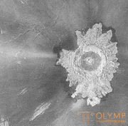
Impact crater on Venus
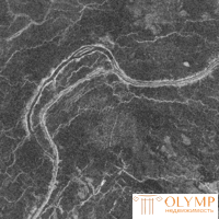
Radar image of lava flow channels on Venus
In the 1970s, the Pioneer-Venera-1 AMS radar captured the surface of Venus with a resolution of 150-200 km. Soviet AMS Venera-15 and Venera-16 in 1983-1984 with the help of radar mapped most of the northern hemisphere with a resolution of 1-2 km, for the first time filming tesserae and crowns. The American "Magellan" from 1989 to 1994 made a more detailed (with a resolution of 300 m) and almost complete mapping of the planet's surface. Thousands of ancient volcanoes erupting lava, hundreds of craters, arachnoids, mountains were discovered on it. The surface layer (crust) is very thin; weakened by high temperature, it weakly prevents the lava from breaking out. The two Venusian continents - the Land of Ishtar and the Land of Aphrodite - are no less than Europe in area, but their length is somewhat larger than the Parge canyons, named after the mistress of the forest among the Nenets,which are the largest detail of the relief of Venus. Lowlands, like ocean trenches, occupy only one-sixth of the surface on Venus. The Maxwell Mountains on Ishtar Land rise 11 km above average surface level. The Maxwell Mountains and the Alpha and Beta regions are the only exceptions to the IAU naming convention. All other regions of Venus are given female names, including Russians: on the map you can find the Land of Lada, the Snegurochka plain and the Baba-Yaga canyon [57].All other regions of Venus are given female names, including Russians: on the map you can find the Land of Lada, the Snegurochka plain and the Baba-Yaga canyon [57].All other regions of Venus are given female names, including Russians: on the map you can find the Land of Lada, the Snegurochka plain and the Baba-Yaga canyon [57].
Impact craters are a rare element of the Venusian landscape: there are only about 1000 of them on the entire planet. The picture on the right shows the Adyvar crater with a diameter of about 30 km. The inner area is filled with solidified rock melt. The "petals" around the crater are formed by shattered rock thrown out during the explosion during its formation.
Features of the nomenclature
Since the clouds hide the surface of Venus from visual observations, it can only be studied by radar methods. The first, rather rough, maps of Venus were compiled in the 1960s. based on radar conducted from the ground. Parts of hundreds and thousands of kilometers, bright in the radio range, received conventional designations, and at that time there were several systems of such designations that did not have a general circulation, but were used locally by groups of scientists. Some used the letters of the Greek alphabet, others - Latin letters and numbers, others - Roman numerals, the fourth - naming in honor of famous scientists who worked in the field of electrical and radio engineering (Gauss, Hertz, Popov). These designations (with some exceptions) have now gone out of scientific use, although they are still found in modern literature on astronomy.[58] Exceptions are the Alpha Region, the Beta Region and the Maxwell Mountains, which have been successfully compared and identified with refined space radar data [59].
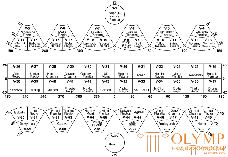
Scheme of dividing the map of Venus into sheets (each has an alphanumeric designation and a Latin name for a remarkable relief detail)
The first map of part of the Venusian surface using radar data was compiled by the US Geological Survey in 1980. The information collected by the Pioneer-Venera-1 (Pioneer-12) radiosonde, which operated in the orbit of Venus from 1978 to 1992, was used for mapping.
The rules for naming the details of the relief of Venus were approved at the XIX General Assembly of the International Astronomical Union in 1985, after summarizing the results of radar studies of Venus by automatic interplanetary stations. It was decided to use only female names in the nomenclature (except for the three historical exceptions cited earlier) [58]:
Like the Earth, the Moon and Mars, the geological history of Mercury is divided into periods (the concept of eras is used only for the Earth). This division is established by the relative age of the details of the relief of the planet. Their absolute ages, measured in years and estimated from the concentration of craters, are known with low accuracy. These periods are named after characteristic craters. Their sequence (from earlier to later, with dating of the beginning): pre-Tolstoy (~ 4.5 billion years ago), Tolstoy (4.20-3.80 billion years ago), Calorian (3.87-3.75 billion years ago), Mansurian (3.24–3.11 billion years ago) and Kuiper (2.2–1.25 billion years ago).

After the formation of Mercury 4.6 billion years ago, there was an intense bombardment of the planet by asteroids and comets. The last violent bombardment of the planet ended 3.8 billion years ago.
Volcanic activity was probably characteristic of young Mercury. Some regions, for example the Zhara plain, were covered with lava. This led to the formation of smooth plains inside craters, like the lunar seas, but composed of light rocks. Volcanism on Mercury ended when the thickness of the crust increased so much that lava could no longer pour out onto the planet's surface. This probably happened in the first 700-800 million years of its history.
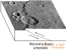
Later, when Mercury cooled down from lava eruptions, its volume decreased, and the stone shell, which cooled and hardened earlier than the bowels, was forced to shrink. This led to the cracking of the outer rocky crust of the planet and creeping from one edge to the other with the formation of a kind of "scales" in which one layer of rocks is pulled over another. The upper layer, advancing to the lower one, acquired a convex profile, resembling a frozen stone wave. Traces of such movements are still clearly visible on the surface of Mercury in the form of ledges several kilometers high, with a sinuous shape and a length of hundreds of kilometers. Such a compression of the planet's crust was certainly accompanied by strong earthquakes. In 2016, it was discovered that tectonic activity on Mercury has occurred in the last 50 million years.leading to earthquakes of magnitude up to 5 points.
All subsequent changes in the relief are due to impacts on the surface of the planet of outer space bodies.
Mercury manages to run around the Sun in 88 Earth days (the year of Mercury). But a solar day (rotation around its axis) is no less than 176 Earth days. It turns out that solar days are 2 times longer than a year on Mercury!
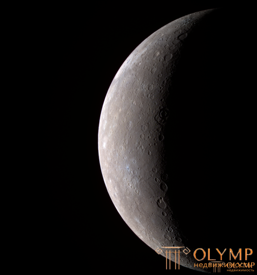
Fig The first high-resolution images of Mercury obtained by the Messenger, January 22, 2008
Although the density of Mercury is close to that of the Earth, the force of gravity on it is only 38% of the force of gravity on Earth. The conditions for the formation of soils (dismembered relief, a very thin helium atmosphere, the presence of a large number of meteorite craters and manifestations of volcanic activity) are very similar to those of the moon.
The surface of Mercury resembles the lunar in many ways - it is heavily cratered. The density of craters on the surface is different in different areas. From young craters, as well as from craters on the Moon, light rays stretch in different directions. It is assumed that the more densely cratered areas are older, and the less densely covered areas are younger, formed by flooding of the older surface with lava. At the same time, large craters are less common on Mercury than on the Moon. The largest crater on Mercury is the Heat Plain basin (1525 × 1315 km). Among the craters with its own name, the first place is occupied by the half-size Rembrandt crater, its diameter is 716 km [79] [80]. However, the similarity between Mercury and the Moon is incomplete - there are formations on Mercury that are not found on the Moon.
An important difference between the mountainous landscapes of Mercury and the Moon is the presence on Mercury of numerous jagged slopes, stretching for hundreds of kilometers, - ledges (scarps). The study of their structure showed that they were formed during compression, accompanying the cooling of the planet, as a result of which the surface area of Mercury decreased by 1%. The presence of well-preserved large craters on the surface of Mercury suggests that over the past 3-4 billion years there has been no large-scale movement of parts of the crust, and there has been no erosion of the surface, the latter almost completely excludes the possibility of any significant existence in the history of Mercury. atmosphere.
Thanks to the Messenger probe, which captured the entire surface of Mercury, it was revealed that it is homogeneous. In this respect, Mercury is not similar to the Moon or Mars, in which one hemisphere differs sharply from the other [45]. The highest point on Mercury (+ 4.48 kilometers above average) is located south of the equator in one of the oldest regions on the planet, and the lowest point (-5.38 kilometers below average) is at the bottom of the Rachmaninov Basin, surrounded by a double a ring of mysterious mountains, which, according to scientists, are one of the last volcanic manifestations on the planet [81].
The first data on the study of the elemental composition of the surface using an X-ray fluorescence spectrometer of the Messenger apparatus showed that it is poor in aluminum and calcium in comparison with the plagioclase feldspar characteristic of the continental regions of the Moon. At the same time, the surface of Mercury is relatively poor in titanium and iron and rich in magnesium, occupying an intermediate position between typical basalts and ultrabasic rocks such as terrestrial komatiites. A relative abundance of sulfur was also found, which suggests reducing conditions during the formation of the planet's surface [78].
Mercury craters
Craters on Mercury range from small, bowl-shaped depressions to multi-ring impact craters hundreds of kilometers across. They are in different stages of destruction. There are relatively well-preserved craters with long beams around them, which were formed as a result of the release of matter at the time of impact. Some craters are very badly destroyed. Mercury craters differ from lunar craters in the smaller size of the surrounding ejection halo, due to the greater gravity on Mercury [65].
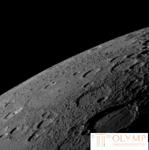
The surface resembles a lunar (image of the AMC "Messenger")
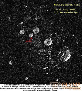
Radar image of the craters of the north pole of Mercury
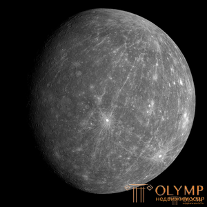
Kuiper Crater (just below the center) (image of the AMS "Messenger")
One of the most noticeable features of the surface of Mercury is the Plain of Heat (Latin Caloris Planitia). It got its name because it is located near one of the "hot longitudes". This lava plain fills a crater (impact basin) measuring 1525 × 1315 km - the largest on the planet. Its rampart in places (Zhary mountains) exceeds 2 km. In the center of the plain there is a peculiar system of furrows, called the Pantheon [79] [80] (unofficial name - "Spider").
Probably, the body, upon impact of which the crater was formed, had a diameter of at least 100 km. The impact was so strong that seismic waves passed through the entire planet and, focusing at the opposite point of the surface, led to the formation of a kind of crossed "chaotic" landscape here.
The brightest part of the surface of Mercury is the 60-kilometer Kuiper Crater. This is probably one of the youngest large craters on the planet [82].
The rules for naming the details of the relief of Mercury were approved at the XV General Assembly of the International Astronomical Union in 1973:
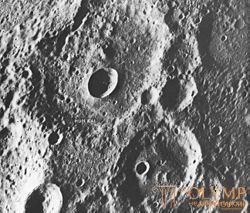
Small crater Hun Kal (indicated by an arrow), which serves as an anchor point for the system of longitudes of Mercury. Photo of AMS "Mariner-10"
There are also some characteristic features of the relief, for example, the strange 2-3-kilometer cliffs stretched for thousands of kilometers. This landscape element, as can be seen, is associated with tectonic movements of the planet's mass. Fluctuations between daytime and nighttime temperatures reach significant values: during the day up to plus 345 ° С, and at night up to minus 180 ° С. Now it is believed that the soils of Mercury are very close to the lunar ones. There are rocky igneous rocks such as basalts. Most likely, loose soils formed as a result of impacts of meteorites and processes of physical (thermal) weathering are widespread.
Discovered on Mercury and "mascons". This allows us to assume the presence of sandy-detrital soil of significant thickness.
Что бы оставить комментарий войдите
Комментарии (0)