15.1. The concept of zooming
Multiscope shooting is associated with obtaining a topographic plan directly in the field. At the same time, horizontal angles are not measured, as in a total station survey, but are obtained from graphical constructions; therefore, it is also called acrobatic .
15.2. Set of Menzula.
Bottom imaging is performed using a set of instruments and accessories. The set of gauges (Fig. 94) includes: a bent-metal fork with a centering fork and a plumb line, a kipregel, a landmark - a compass, a gauge rail and a field umbrella.
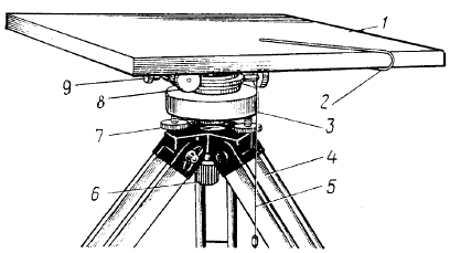
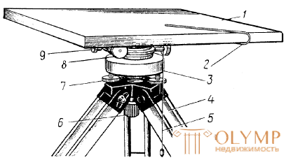
Menzula (Fig. 94, a) (from the Latin. Mensula - table). It consists of a tripod, a stand and a scale board - a tablet. On the tablet is fixed a drawing paper on which a plot plan is drawn.
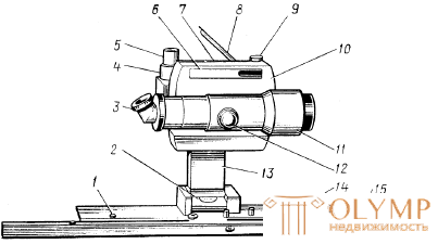
Kipregel (Fig. 94, b) (kippen - from it. Tilt and regel - ruler) - a device for surveying the terrain. Cypregel sights on points of terrain, tracing directions on a tablet, measure vertical angles and distances or their horizontal distances.
At present, KP and KNK cypregels are produced. Both autoreduction kipregel. They define elevations and distances reduced by the horizontal plane.
Kipregeli have the following parts: telescope, column and ruler. The telescope rotates relative to the vertical circle, which allows, when it slopes, to see in the field of view different parts of the circle with nomograms of curves (Fig. 95).
but)  b)
b) 
Fig. 94. The mezulny set:
a) a frame with a centering fork: 1 - a scaler board-tablet; 2 - centering fork; 3 - stand; 4 - tripod; 5 - cotton plumb fork; 6 - set screw; 7 - lifting screw; 8, 9 - suggestive and anchoring screws of the stand;
b) Kipregel KN: 1 - scale bar; 2 - level at the column; 3 - eyepiece; 4 - pipe clamp screw; 5 - suggestive screw pipe; 6 - the level of the vertical circle; 7 - level of the telescope; 8 - mirror for observing the level at the pipe; 9 - suggestive screw level of the vertical circle; 10 - vertical circle; 11 - telescope; 12 - creamer; 13 - column; 14 - the base; 15 - additional line
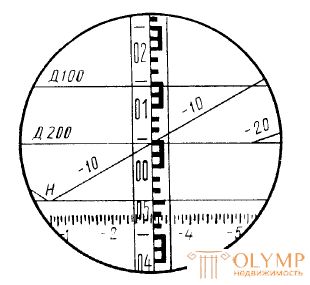
Nomograms of elevations and distances are applied to the surface of a glass vertical circle. Their image is transmitted using a system of prisms in the field of view of the pipe and is projected onto the image of the terrain (Fig. 95).

Fig. 95. The field of view of the telescope Kipregel KN
The sign (-) in front of the coefficient of elevation curves shows a decrease in terrain, and (+) - an increase.
The initial circle of the nomogram is denoted by the letter H with digitized divisions of the limb of a vertical circle through 1 ° and not digitized through 5 '.
The value of the location of zero vertical circle is determined by the formula
 .
.
The slope is calculated by the formula
 .
.
15.3. Shooting substantiation of the shooting.
Boundary shooting is made on the basis of a geodetic reference network. The network can be in the form of theodolite moves, izmenulnyh moves, geometric network.
The crawl course is a series of points fixed on the ground, the planned position of which on the tablet is obtained graphically with the help of menzules and kipregel.
15.4. Shooting the situation and terrain.
The shooting of the situation and the relief is done, like in a tacheometric survey, in a polar manner with a vertical circle of the kipregel to the left of the observer.
By setting the scale over the shooting point, the tablet is centered, leveling and orienting.
For centering the tablet is pre-oriented to the eye and, acting with the legs of the tripod, the menzula bring it to a horizontal position. At the same time make sure that the corresponding point of the tablet is approximately above the terrain point.
When shooting 1: 2000 and larger, the scale is centered using a centering fork, and when shooting 1: 5000 and smaller - by eye.
Horizonate the plate with a cylindrical level on the kipregel line.
Orient the tablet or with the help of a guideline - compass or along the direction marked on the tablet.
Rack points are chosen at characteristic places and above this point they vertically hold the rangefinder rail.
Having attached the beveled edge of the kipregel ruler to the point of a removable justification, the telescope is visualized by the kipregel to the point to be removed and take the distance S and h in excess by nomograms. After removing a few points, the situation is drawn, and the heights are interpolated to the heights of the points.
The choice of rack points (pickets) is done in the same way as in the tacheometric survey. In the process of shooting, every day after fieldwork, tracing heights is filled, inflicting all the rack points with their heights on it, and make up the tracing of the contours of the situation.
Tracing paper needed to control the drawing of tablets and restore accidentally erased points on the tablet during field work.
Mozule shooting with simultaneous shooting of the situation and the relief is currently rarely used, it is usually used for shooting the relief on ready-made contour plans or photo plans, i.e. in the production of a combined survey area.
15.5. Questions for self-control
1. What is the purpose of frame shooting?
2. What devices are included in the set?
3. What types of shooting justification can be created during a timeline?
4. For what scale of the survey can the centerline be centered with a centering fork and by eye?
5. What are the advantages and disadvantages of a bulk survey?
Что бы оставить комментарий войдите
Комментарии (0)