3.1 Groundwater
Water in nature is widespread. It is contained in the atmosphere, hydrosphere and biosphere.
Rocks in their origin and due to secondary processes (weathering, leaching, tectonic movements, etc.) are not monolithic, but contain pores, voids and cracks of various shapes and sizes. This facilitates the infiltration of precipitation and the condensation of water vapor in the weathering crust, contributing to the formation of aquifers in it. Waters can flow down the slope of the roof of impermeable, dense, not weathered or poorly affected by weathering rocks. The waters in the upper part of the lithosphere are called subsurface. Groundwater plays a large role in human life and economic activity.
For builders, groundwater serves as either a source of water supply, or acts as a factor hampering construction.
Especially difficult is the production of earthworks and mining in the conditions of the flow of groundwater, flooding the pits, quarries, and other types of workings. The appearance of groundwater in loose rocks leads to a deterioration of their physical and mechanical properties. In clayey rocks, saturation with water, as a rule, leads to flowability, and in sandy rocks, to flowability. In limestone, gypsum, rock salt, groundwater causes the substance to dissolve to form large voids.
The types of water, depending on the condition of the water in the soils, are classified as follows: vaporous; bound - strongly bound (hygroscopic), loosely bound; free - capillary, gravitational; in the solid state (ice); crystallization and chemically bound
Vaporous water. Along with other components, water vapor is a part of the ground atmosphere. Typically, the amount of water vapor in the soil does not exceed a thousandth of a percent of the total weight of the soil. However, water vapor plays an important role in the processes occurring in soils, due to the fact that it can move freely in the soil with its insignificant moisture (which distinguishes it from all other types of water in the soils), and also because during the condensation of steam on the surface of the soil particles form other types of water.
Vaporous water in the soil is in constant dynamic equilibrium with other types of water, for example, with hygroscopic and with water vapor in the atmosphere. Vaporous water can condense under certain conditions.
The possibility of the formation of other types of vaporous water is related to the ability and intensity of adsorption of vaporous water by mineral particles.
The intensity of adsorption is determined by various factors, in particular, it depends on the relative elasticity of water vapor. With the growth of elasticity, the amount of adsorbed moisture increases. About 50% of the condensation water is adsorbed on the surface of the soil particles, and the remaining part is condensed in the micropores of the soil, where it passes into the bound water.
A feature of the adsorption of water vapor on the surface of soil particles is that, in addition to individual molecules, complexes of water vapor molecules are formed, and this affects both the amount of adsorbed moisture and the intensity of its interchange with the ground atmosphere and with the atmosphere in general.
The mobility of vaporous moisture in certain conditions affects the properties of soils, especially clay, loess, where it affects their natural moisture.
Bound water At the beginning of our century, experts who studied the behavior of soils and soils, found that mineral particles in them are surrounded by a number of concentric layers of water. The layers of water are retained by particles with different strengths depending on how close this layer of water is to the mineral particle: the closer, the stronger it is associated with it.
Modern studies have confirmed the above assumptions, and it was found that the connection between water films and mineral particles is due to molecular forces. Bound water is more than 40% of all water contained in clay rocks. The presence of various categories of bound water in soils of any composition drastically changes their state and properties.
By its characteristics, bound water differs significantly from free water (in particular, from that which we know in everyday life). Its average density lies in the range of 1.20–1.40 g / cm3. It is interesting to note here that with existing methods, for example mechanical, it is possible only to condense water into fractions of a percent, and usually in all calculations in the range of loads arising in construction practice, water is taken as a practically incompressible fluid. Bound water moves in soils in the direction of falling electrical potential, increasing the dispersion of soil, a higher content of clay minerals, in the direction of falling temperatures of the soil. Bound water freezes at temperatures close to - 4 ° C.
Bound water can be subdivided into tightly bound and loosely bound.
Strongly bound water. The maximum amount of tightly bound water in the soil roughly corresponds to the maximum hygroscopicity, i.e., to the soil moisture that is formed during adsorption of vaporous moisture by soil particles with a relative elasticity of 100%.
Strongly bound water itself has several varieties, each of which significantly affects the properties of rocks; For example, the so-called basal surface water of clay minerals (surfaces perpendicular to the ribs and chips of their crystal lattice) forms solid films of water around clay particles, as a result, the value of the bond between individual particles decreases, which leads to a decrease in the strength of clay soils. With full content of all types of tightly bound water, i.e. with humidity close to maximum hygroscopicity, the indicated loss of strength by clay soils is very significant.
The content of strongly bound water in dispersed soils is determined by their mineralogical composition, dispersion, degree of homogeneity, shape and character of the surface of mineral particles, as well as the composition of exchangeable cations in them.
Depending on the complex of factors, the content of strongly bound water lies in the range of 0.2–30% (in montmorillonite clays, the content of this water reaches 20%, and in kaolinite only about 1%).
Loosely bound water differs in its properties from strongly bonded water, for example, it has a density close to that of free water. Let us dwell on this kind of water in more detail. Loosely bound water is divided into film and osmotic. Moisture film as if envelops itself tightly bound and held by molecular forces to a much lesser extent, although the nature of its interaction with particles is very close to the behavior of strongly bound moisture, but it is more mobile and the dipoles of water molecules in the water shell are relatively worse than soil particles. The total content of all types of tightly bound and film water is moisture, which is called the maximum molecular moisture capacity of soils Wm.m. The value of the maximum molecular moisture capacity shows how much bound water is contained in the soil under the influence of the surface attractive forces of the soil particles. The average molecular moisture capacity in sand is about 1–2% on average, and in montmorillonite clays it can reach almost 135%.
Osmotic water is formed as a result of the penetration of water molecules from soil solutions. This type of water is very weakly associated with the surface of soil particles, its mobility is very close to the mobility of free water and is almost the same in structure and properties.
The presence of osmotic moisture in soils determines, especially in clay soils, their plasticity in the humidity ranges that are quite specific for different soils.
Free water. Consider first the capillary moisture.
Capillary water is divided into three types: 1) pore angle water; 2) suspended water; 3) capillary water itself.
The first type of water (water of pore angles, or butt water) is sometimes referred to as capillary-separated water or capillary non-moving state of free ground water. These names are quite clearly characterized by this type of water. Water pore angles are usually formed at the points of contact — at the contacts of particles — in the form of individual droplets occupying narrowed portions of the pores and bounded by meniscuses. The content of this type of water, for example in sands, is 3–5%, in sandy sands - 4–7%. With increasing dispersion, the amount of water increases to a certain limit.
With an increase in soil moisture, the capillary pores can be completely filled with water, in this case, the capillary water is divided into capillary and suspended water itself (depending on whether it connects to the groundwater level or not.)
Actually capillary water is formed by raising water up from the groundwater level, forming a capillary rim under the groundwater in the soil mass. The power of the capillary border is determined by the height of the capillary rise of Hk . Capillary elevation depends on a number of factors, for example, the degree of dispersion, heterogeneity of the soil, its mineralogical composition, the shape and nature of the surface of soil particles, the density and porosity of the soil (for example, in sand it is 50 cm on average, and in sandy and other clay soils up to 2 - 3 m).
With a decrease in capillary water due to the drying of the soil, its recovery is observed due to the rise of new portions of water from aquifers through the capillary pores, just as it happens in a capillary tube, lowered at one end into the water.
The moisture content of the soil, in which all the capillary pores are filled with water, is called capillary moisture capacity, which depends on the same factors as the height of the capillary rise, as well as such specific characteristics as capillary porosity.
When soil is soaked from above, for example, during precipitation, during erection of soil dams by hydromechanization or dumping, when wetting and rolling the soil, as well as in other cases arising in construction practice, suspended water is formed in the soil . Most often, its formation occurs in sands, both in homogeneous and layered sequences. The formation of suspended water depends on the particle size distribution of the sand and its initial moisture content.
The greatest amount of suspended moisture that can be held by the soil is called the least water-holding capacity or the water-holding capacity of the soil. All the moisture that enters the soil above the value of the smallest water holding capacity flows down the pores to the underlying layers of the massif or layered strata of soil.
Capillary water, like gravitational water, transmits hydrostatic pressure; according to other properties, it has both similarities and differences, for example, the freezing point of it, like that of bound water, can be significantly below zero.
This water is able to move due to the temperature difference (from cold to heat), dissolve and transfer salts; when water evaporates, these salts crystallize and thus destroy the structure of soils and building materials, for example, in road pavements.
We now turn to the consideration of gravitational water, which is subdivided into: 1) leaking and 2) groundwater.
The first type of water is predominantly located in the aeration zone (the aeration zone is a part of the soil massif located between the ground and the groundwater surface; in this zone the ground is in a three-phase state: mineral particles — air — water) and moves under the influence of gravitational force from top to bottom. This movement continues until the water meets on its way a layer of soil with low permeability - in fact, waterproof, impermeable horizon. After that, the further movement of water occurs under the influence of pressure in the form of a flow of groundwater. The layer of soil in which the water of the groundwater flows is called the aquifer.
The amount of gravitational water in various soils of dispersion and inhomogeneity may be different: for example, in coarse-grained soils (gravel, pebble) and in coarse-grained sands, gravitational water prevails over other types of water.
The maximum possible content in the soil of bound, capillary and gravitational water with full filling of its pores is called the full capacity of the soil.
Gravitational water has all the properties of ordinary water. It contains dissolved salts and gases, as well as substances in a colloidal state. Total mineralization ranges from a few hundred milligrams to several hundred grams per liter, for example, the salinity of sea water is 35 g / l.
Groundwater salinity increases with depth. Salts dissolved in water are in mobile equilibrium with the solid component of soils and interact with it.
Gravitational water is almost always in motion. The problems of the dynamics of groundwater and their influence on the construction properties of the massifs and layered strata of soil are handled by hydrogeology. Moving water is capable of dissolving rocks, removing particles from them, i.e., changing the structure and composition of soils, forming and activating geological processes.
Water in solid form. At temperatures below zero, gravitational water freezes and is contained in the soil in the form of ice. Ice can form in the ground as interlayers of various, sometimes of considerable thickness, as well as scattered in its thickness individual crystals. Crystalline ice in most cases plays the role of natural cement, bonding mineral particles with each other.
The presence of ice dramatically changes the properties of the soil.
The properties of frozen loose soils depend on temperature changes, especially when it fluctuates around 0 ° C, since the amount of unfrozen water in the soil dramatically changes near this boundary. The ratio of the content of unfrozen water and ice in the ground affects the change in most of the physical and chemical properties of dispersed frozen soils.
A sharp change in the structure of the soil occurs during the migration of moisture and ice release in the process of freezing of dispersed, especially clay, soils. These changes entail a natural change in the physical and mechanical properties of the soil. It should be borne in mind that the re-freezing and thawing of dispersed rocks lead to irreversible changes in the structure (including the degree of dispersion) and properties of these rocks, for example, the amount of free water increases, filtration capacity increases, strength, electrical and other properties change. .
Wet sandy soils during freezing dramatically change their properties already at negative temperatures close to zero; clay soils during freezing change their properties more smoothly, monotonously and in a more significant range of negative temperatures. Unbreakable rocks during freezing change their physical and mechanical properties to the least extent. Permafrost is studying the properties of frozen soils. Frozen soils are widely distributed in Russia, so they are used very often in construction. In addition, large areas of the country belong to the climatic zones where the soils experience constant (annual) seasonal freezing and thawing.
Crystallization and chemically bound water. Crystallization and chemically bound water, often called constitutional, participates in the formation of crystal lattices of various minerals. So, water is a part of such minerals as gypsum (CaS04 · 2H20) and some others. Crystallization water, participating in the construction of the crystal lattice of minerals, retains its molecular shape.
Chemically bound water is part of such compounds as, for example, limonite (Fe203 · n Н20). This water does not preserve its molecular unity, but more firmly, as compared to crystallization, is associated with other molecules of the crystal lattices.
In order to remove chemically bound water from a mineral, it must be heated to about 200 ° C, and this may lead to decomposition (destruction) of the mineral.
In chemically bound water, unlike crystallization water, in some cases, the hydrogen ion can be replaced by a metal ion (Ca, Mg, Na, K, Fe).
Chemically bound and water of crystallization or one of them is present in secondary minerals. Among the primary minerals are a significant amount of anhydrous. Therefore, in clay soils, water entering the crystal lattices of minerals plays a more significant role than in sandy ones.
The science of hydrogeology is concerned with the study of the origin of groundwater, the movement, composition and their properties.
Groundwater is classified by hydraulic characteristics, temperature, chemical composition, etc.
Hydraulically divided into: non-pressure, pressure.
1. Not pressure water:
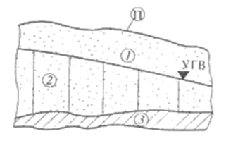
- Groundwater is above the first water perch from the surface; различают: зону аэрации, зону насыщения, кона капиллярного поднятия (кайма) (рисунок 18).
- Верховодка – накапливается в зоне аэрации над ограниченными по площади водоупорами; носит сезонный характер и непостоянный химический состав;
- Межпластовые воды - залегают между двумя водоупорами, питание идет в местах выклинивания верхнего водоупора или его размыва.
2. Напорные воды. Условия залегания - наличие водоносного горизонта между двумя водоупорами при пликативных дислокациях – моноклинального или антиклинального залегания слоев, когда области питания по абсолютным отметкам выше областей дренирования
(рисунок 19, 20).
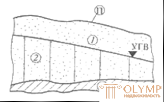
Рисунок 18 - Грунтовая вода: 1 – уровень грунтовых вод (УГВ); 2 – мощность рунтовой воды; 3 –
ложе (водоупор); П – поверхность земли
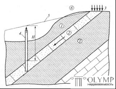
Рисунок 19 - Артезианская вода при моноклинальном залегании слоев:
1 – водоупоры; 2 – водоносный слой; 3 – область питания водой;
4 – буровая скважина; 5 – пьезометрический уровень;
6 – поверхность земли;
Н – высота (величина) напора воды
По температуре:
- холодные t ‹ 200С
- теплые t 200 – 400С
- горячие t › 400С
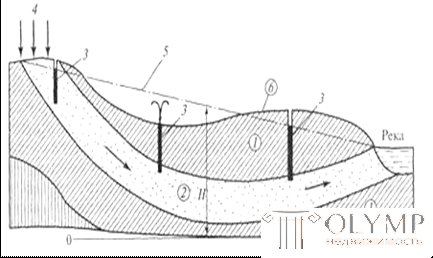
Рисунок 20 - Артезианский бассейн (в условиях синклинального залегания слоев пород):
1 – водоупор; 2 – водонапорный слой; 3 – буровые скважины;
4 – область питания водой; 5 – пьезометрический уровень; 6 – поверхность земли; Н – высота (величина) напора воды
При строительстве фундаментов и подземных сооружений в зоне влияния подземных вод последние анализируются на предмет их агрессивного воздействия на конструкции. Виды агрессии: общекислотная, углекислая, сульфатная, магнезиальная, выщелачивающая. Расчеты проводят по нормативным документам. В зависимости от вида агрессивности грунтовых вод принимаются мероприятия по защите конструкций.
Возраст грунтовых вод определяется по возрасту вмещающих пород. Например, юрские, четвертичные и др.
Свободную поверхность грунтовых вод называют зеркалом или уровнем грунтовых вод. По условиям своего залегания эти воды могут образовывать потоки, озѐра или бассейны. Территория, на которой воды просачиваются в горные породы, называется областью питания. Площадь, в пределах которой они залегают, называют областью распространения. Местность, где грунтовые воды выходят на поверхность, называют областью дренажа. Поверхностные слои горных пород, не содержащие свободную воду, называют зоной аэрации.
Уровень грунтовых вод не остаѐтся постоянным. Его колебания зависят от времени года, количества выпадающих осадков, расположения участка относительно поверхностных водоѐмов или постоянных водотоков. Кроме того, как показал опыт строительства во многих городах, уровень грунтовых вод значительно повышается в результате инфильтрации промышленных и питьевых вод при эксплуатации инженерных водоводов.
Знание режима, направления движения и скорости движения по-
тока грунтовых вод имеет важное значение для строительства.
Например, по результатам изысканий, выполненных в засушливое время года, будет дано заключение о глубоком залегании грунтовых вод. Однако при таянии снегового покрова или в дождливый сезон уровень грунтовых вод резко повысится и может вызвать затруднения не только в период строительства, но и при эксплуатации сооружения. При утечке неочищенных сточных вод происходит загрязнение грунтового потока и очень важно, чтобы эти воды не проникали в санитарные зоны и области питания водозаборных скважин.
3.2 Гидрогеологические карты и динамика подземных вод
Для оценки гидрогеологических условий местности, выявления возможностей водоснабжения, устройства полей фильтрации, орошения или осушения территории, а также борьбы с карстовыми провалами и оползнями составляются гидрогеологические карты.
Из всех видов специальных гидрогеологических карт наибольший интерес и практическое значение для инженерных целей имеют карты гидроизогипс.
При отсутствии карты гидроизогипс для решения гидрогеологических задач, определения направления движения грунтовых вод и анализа гидрогеологических условий применяют метод скважин. Замеры уровня грунтовых вод делают обязательно в одно и то же время во всех трѐх скважинах. Скважины располагают по углам треугольника, длина сторон которого обычно от 50 до 300 м.
Hydro-isohypsis is a line connecting the same levels of non-pressure groundwater. The direction of flow is defined as the shortest distance between two hydroiso-gypsums anywhere on the site. The stream is directed from the larger hydroisogips to the lesser. Depending on the position of the current lines, the flat (a) current flows are parallel to each other, the radial (b, c) current lines diverge (divergent) or converge (convergent), curvilinear (d). If there are several types of flows in one, it is called complex (Figure 21).
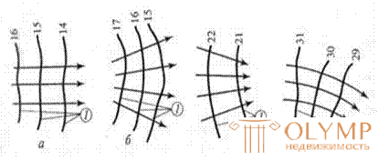
Figure 21 - Forms of groundwater flows:
a - flat; b - radial divergent; в - radial convergent; g - curvilinear
Types of water intakes
Water intakes can be perfect when the entire aquifer is passed through a well or a well and the inflow of water goes from the walls to the entire thickness of the aquifer and imperfect when the aquifer is not completely opened and the inflow from the bottom of the well and from the walls to the exposed capacity (Figure 22 ).
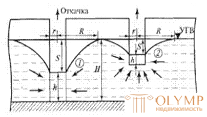
Figure 22 - Water intake wells of perfect (1) and imperfect (2) species
The movement of groundwater in the pores and cracks in the aeration zone occurs when the pores are not completely filled with water and is called infiltration. In the zone of saturation of the movement of groundwater occurs when the pores are completely filled with water, it is called filtration and obeys the Darcy law.
Q = k J w;
where Q is the water flow in m3 / day;
w is the cross section of the aquifer, m2; k is the filtration coefficient characterizing water permeability
bridge of breed, m / day;
J - pressure ratio - loss of pressure per unit path length, the dimensionless value.
Что бы оставить комментарий войдите
Комментарии (0)