4.1 Processes and phenomena
Exogenous processes (processes of the Earth’s external dynamics) are the result of geological activity of wind, ice, sea, and flowing waters. Their main driving force is the energy of the sun, the processes of gravity and magnetism, the interaction of geospheres.
Exogenous processes arising and developing as a result of human economic or construction activity are called engineering-geological.
Table 5 - Groups of geological processes and types of phenomena
(according to V. D. Lomtadze)
4.2 Weathering Processes
By weathering is understood the destruction of rocks under the influence of temperature, oxygen, carbon dioxide in air and in water, as well as various organic substances formed during the life of plants or during their dying off and decomposition.
Weathering proceeds most actively near the surface of the Earth, where rocks are directly affected by atmospheric, hydrospheric, and biospheric insolations.
There are types of weathering: physical, chemical, organogenic. Physical weathering causes the destruction, crushing of rocks into individual angular fragments of different sizes. In the vertical section, several subzones of weathered material are distinguished, differing from each other in different degrees of rock crushing (Figure 23). Directly above the unweathered rock, there is a coarse-clastic, or blocky subzone, which is replaced by a small-grained, or crushed-stone subzone from above, and the zone of finer and finer crushing is located above (Figure 23).
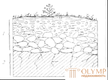
Figure 23 - Scheme of weathering of soil rocks:
1 - weathering crust; 2 - bedrock
(breed untouched by weathering)
The physical type of weathering is characteristic of high mountain regions and regions with a sharply continental climate.
Chemical and organic weathering. In these cases, elements of rock-forming minerals react with environmental elements, and as a result of oxidation, hydration, dissolution and hydrolysis reactions, secondary mineral formations are formed that are more stable in the new environment.
In nature, all types of weathering almost always occur simultaneously.
with the prevalence of one type or another, depending on the geological, geographical and climatic conditions.
The destroyed material is partially carried away by water and air streams, and the rock remaining at the site of destruction is called eluvium. The lower boundary of the eluvium does not usually repeat the day surface. Protrusions of weathered rock are formed into the depths of fresh rock in the form of craters, tongues and wedges. Observed in areas of change of rocks of different resistance or fracture. Weathering lugs pointing downward are called pockets. As a result of the weathering of rocks, over time, massive strata of eluvial rocks that form the weathering crust accumulate on the surface of the massif .
Weathering processes are actively developing in open construction pits, trenches, with long-term construction. Building structures are also exposed to weathering, which are covered with protective films and solutions.
4.3 Geological activity of the wind
One of the land-forming factors is the wind. Especially intense is its activity in deserts and semi-deserts, occupying about 20% of the continents surface. This is facilitated by sharp daily fluctuations in temperature, causing active processes of physical weathering, evaporation, in many ways exceeding the amount of precipitation falling in the absence or sparseness of vegetation cover. In addition, the active work of the wind is manifested in the uncovered coasts of the seas and some large rivers. All processes caused by wind activity are called eolian. Continental sediments arising from wind accumulation and the corresponding landforms are also referred to as eolian deposits: sand dunes, dunes, and hillocks. The wind is the movement of air in the atmosphere, almost parallel to the earth's surface. The wind arises due to the uneven horizontal distribution of pressure, which, in turn, is caused by the inequality of temperatures in the atmosphere, the wind is characterized by speed and direction.
Wind activity consists of deflation (blowing and waving), corrosion (grinding), transfer and accumulation (accumulation). This is a complex process. One can only say that in some places one type of wind activity prevails, in others - other.
Deflation - occurs as a result of the influence of the mechanical force of the wind. The rocks are blown out, i.e. particles are torn off and carried away. This process is most clearly manifested in areas composed of loose and soft rocks. The wind blows pits, grooves and trenches in salt marshes, silty loam, sand, in the arable layer. Blowing or deflation is greatly enhanced after a violation of the turf cover, cutting down bushes and trees. The mechanical force of the wind creates a wind load on buildings and structures that must be considered in the design and construction.
Corrosion - transferring sand and constantly striking with sand grains on rocky protrusions, the wind grinds, wears them, drills various holes. The greatest amount of sand, persecuted by the wind, is observed in the lower, surface layers of the air flow it is here that the maximum corrosion occurs. Strong and frequent blows of sand erode the rocks at the base. As a result of corrosion and deflation, rocks appear - remnants, often mushroom-shaped forms. In non-uniform rocks consisting of minerals of varying resistance under the blows of sand grains that receive rotational motion, small holes are drilled — meshes. So there are cellular rock surfaces. The size of wind-borne debris depends on wind speed. So, at a speed of 10 m / s, the diameter of the transferred particles is up to 1 mm, and at a speed of 20 m / s it is already 4 - 5 mm. and at the same time there is a transfer of particles with a diameter of up to 2–3 cm. The distance to which the sandy material is transferred depends not only on the wind speed, but also on the strength of the ascending air flows.
Simultaneously with the deflation and transport of particles by the wind, accumulation occurs, as a result of which special types of continental aeolian deposits are formed.
Sandy aeolian deposits are usually distributed in the immediate vicinity of areas of deflation to a more distant distance, and dust particles are carried by the wind, which, when accumulated, form eolian loess.
Aeolian sands are well rounded, sorted (up to 80-90% diameter of sand grains 0.25 - 0.05 mm), quartz and other stable minerals prevail in the composition. In deserts and semi-deserts, aeolian sediments are mainly represented by sand dunes (Figure 24) . This is a mobile sandy form of relief, transverse to the direction of the wind. Formed at small obstacles then increases due to the brought sandy material. Barchan is an asymmetrical hill with a height of 1–10 m., Up to 150 m (in diameter up to 250 m.) With a full leeward slope and a crumbling leeward slope forming a sharp ridge at the junction. Slope steepness from 28 ° to 38o.
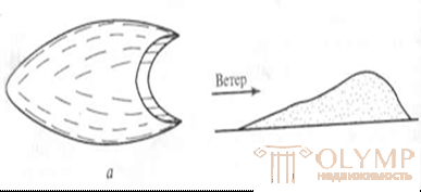
Figure 24 - Barkhan:
a - plan; b - longitudinal section
Dunes are sandy hills resulting from wind activity on the sandy shores of seas, rivers, lakes. The dunes move in the mainstream direction of the wind. Formed from sandy material delivered by the activity of water on the coast, seas, lakes, rivers. On the shores of seas and lakes, the material composition of the dunes is more uniform, while on the river banks it depends on the rocks that form the catchment areas.
Dunes are formed at different latitudes, regardless of climatic conditions. The height of the dunes is from 15 to 30 m., Sometimes up to 75 - 100 m.
Dunes, advancing on the coast, bring large areas, canals, roads, oases, they cause great damage and it is difficult and ineffective to deal with moving sands. Moving sands of dunes and sand dunes, the subsidence properties of eolian loess complicate the construction and operation of facilities in their development areas, special measures are needed to fix the soil and significant financial costs.
4.4 Geological activity of flowing waters
When water moves over the surface of the earth, flushing occurs - displacement of small particles of soil by the streams of rain or meltwater. If flushing occurs without fixing the movement of water - this is plane erosion, which leads to a flattening of the terrain. Washout products - deluvial deposits accumulate in the lowering of the slopes, are represented by loams, less often by clays or sands, and contain coarse fragments. Dyuviya power increases to the base of the slope. The stability of a deluxe slope to landslide depends on the steepness of the buried relief and the presence of the aquifer.
During construction, talus deposits, as a rule, are cut by foundations and the base of the structures are bedrock.
Linear or deep erosion is a vertical erosion. Occurs with easily eroded rocks. Removal of diluvium goes to the base of erosion, i.e., to the surface, at the level of which the stream loses its living force. The erosion is regressive - from the mouth to the headwater. Initially, these are small scours, which eventually turn into steep-walled potholes — ravines (Figure 25.26).
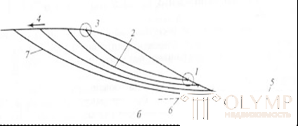
Figure 25 - Longitudinal profile of the ravine:
1 — mouth; 2 - bed; 3 - top; 4 - direction of growth of the ravine;
5 - fan; 6 - basis of erosion; 7 - maximum depth of the ravine
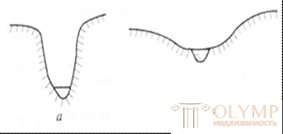
Figure 26 - Cross-section of the ravine: a - active ravine; b - beam
The ravines cause great damage, as they completely destroy the soil layer, break up large tracts into small areas, complicate their configuration, intercept the roads, and carrying out of the ravines - ravine deluvium - introduces usable areas, silt ponds and rivers. When addressing construction issues in ravine development areas, it is necessary to develop anti-erosion measures, taking into account the entire catchment area. With the natural development of ravines, its steep slopes gradually flatten out, overgrow and the ravine turns into a beam. Geotechnical engineering ravines originate and develop as a result of human engineering, when ravines are used to discharge industrial water or surface water runoff when the territory is not properly planned. Such ravines always retain steep sides, increased rates of development and branching. Measures to combat gullying in built-up areas should be timely and effective.
4.5 Geological activity of the river
A river is a water flow flowing in a valley and characterized by a fairly large size (from several kilometers to thousands of kilometers). By the nature of the flow, rivers are distinguished from permanent and periodical; according to the nature of the food they can be rain, snow, glacial, underground and mixed food; according to the conditions of formation - the rivers are flat, mountainous, marsh, karst. Distinguish the source of the river - the place where the river flows from and the mouth - the place where it ends. It may be at the confluence of the final reservoir or another river. In the arid zone of the river sometimes end in a blind mouth. They distinguish the main rivers receiving other tributaries, which are relatively main streams relative to the main river, flowing into first-order tributaries, called second- order tributaries, etc. The totality of all tributaries of the main river makes up the river system.
Each river is characterized by length, width, depth, water flow, solid runoff (sediment) and water chemistry. The line of dip of the channel from the source to the mouth is called the longitudinal profile. The geological activity of a river depends on the flow energy and manifests itself in the form of rock destruction (erosion), transfer of destruction products (transportation) and sedimentation (accumulation). The sediments are called alluvium. Destruction products are transported by rivers in dissolved form, in suspension, and also by dragging along the bottom.
The energy (living force) of the flow (K) depends on the amount of water (m) in the river and the flow velocity (V), which in turn depends on the slope of the river bottom: K = mV2 / 2.
As a result of erosion and accumulation, the river gradually develops a valley with a smooth longitudinal profile along the length of its channel and a gradual flattening of the slopes downstream. This profile is called the equilibrium profile (curve).
The position of the equilibrium profile is determined by the basis of erosion. The erosion basis refers to the basin level into which the river flows and which determines the depth of the bottom erosion along the entire length of the river. The development of a longitudinal profile goes from the basis of erosion towards the river head according to the law of regressive erosion.
After developing the equilibrium profile, the position of the river bed in the lower reaches is close to horizontal, deep erosion almost completely ceases, the period of active development of the river ends, and its aging begins when the river bed often changes its position in a widely developed valley, leaving silted parts of the old bed (old ladies) .
Depending on the geological development of the region and the course of tectonic movements of the earth's crust, the further course of development of the river changes. With vertical uplifts, bottom erosion increases again, the river bed deepens, leaving the previously brought material in the form of longitudinal terraces. The river forms a new understanding and repeats all stages of its development. Lowering the terrain brings with it a change in erosion by accumulation, the previously formed terraces overlap with younger alluvium. The river gradually loses manpower.
The structure of the river valley.
The first terrace rising above the water level is called a floodplain. It is usually flooded with water in a flood. Higher on the side of the valley are floodplain terraces. The closer the terraces are to the riverbed, the younger they are in the accumulation of alluvium. Distinguish between terraces accumulative (nested and leaning), erosive and mixed (Figure 27.28).
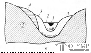
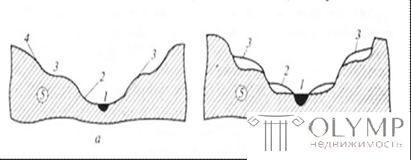
Figure 27 - Types of floodplain terraces:
a - erosion; b - ground; c - accumulative; 1 - channel; 2 - floodplain; 3 - terrace above the floodplain; 4 - the same, the second; 5 - bedrock
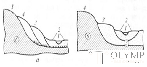
Figure 28. Types of floodplain terraces: a - nested; b - superimposed; 1 - channel; 2 - floodplain;
3-5 floodplain terraces; 6 - bedrock
If the number of terraces of the left and right sides is the same - the valley is symmetrical, if not - asymmetric. The distribution and ratio of terraces of various types and their number is determined by the history of the geological development of the area.
By the nature of precipitation and the place of their accumulation, river sediments are divided into four types:
- Delta - represented by sandy-clay sediments;
- The channel beds are sands, pebbles, in the upper reaches - larger debris and boulders make up islands, rapids, shoals;
- Flooded - sediments are represented by sandy loams, loams, silty sands of different composition, often with organic inclusion;
- C tarry - sediments contain silty sands with a high content of organic matter.
During construction, surveys should be carried out within the limits of each element of the valley. Exploration workings in depth should reveal the full thickness of alluvial sediments of terraces, floodplains, channels. At the same time, generalizing indicators of engineering-geological (construction) properties of soils as bases of structures and a generalization of construction experience should be carried out only within the boundaries of each element, because they each have their own particle size distribution, structure, density, humidity, water content and other indicators, the formation of which occurred in different geological conditions.
4.6 Geological activity of the sea
The geological role of the World Ocean, which currently occupies 36 million sq. M. km, or more than 70.8% of the surface of the globe. About 1.4 billion cubic meters are concentrated in the oceans and seas. km of water. All this mass is in continuous movement and interaction with the rocks of the bottom and coastal zones and produce a huge destructive and creative (accumulative) work. A variety of detrital and dissolved material brought from the land by rivers and obtained as a result of the destructive work of the sea, eventually, is deposited on the bottom of reservoirs, forming sea sediments. The ocean has changed its borders more than once. The entire surface of modern land in the geological past was repeatedly flooded with its waters, powerful strata of sediments were formed at the bottom, which later turned into sedimentary rocks, which often contain minerals, oil, and combustible.
The destructive work of the sea is actively manifested in the coastal zone, which directly refers to the coast and the coastal strip of the seabed. With large storms, the waves hit the coast with a force reaching 30-38 t / m2 in the oceans and up to 15t / m2 in the inland seas.
The destructive work of the sea is called abrasion. The coasts composed of sedimentary rocks are especially intensively destroyed, and to a lesser extent - igneous rocks. The erosion rate of the sea coast at different sites is different, on the Baltic Sea - 0.5 mm / year, on the English Channel 2 mm / year, p. Medoc (France) to 35mm / year. As a result, underwater sea terraces are formed, slightly inclined to the sea. Узкая полоса между подводной террасой и береговым уступом называют пляжем. Скорость абразии зависит от силы удара волны, прочности пород берега и условий их залегания. При падении слоев к морю абразия идет медленнее, при падении в сторону берега, при прочих равных условиях, разрушение берега идет быстрее.
Весь материал - принесенный, растворенный, обрушенный, море переносит, сортирует и откладывает (аккумулирует) вновь в определенных фациальных условиях: мелководной (литоральная зона) и глубоководной зон. В литоральной зоне, границы которой определяются максимальным приливом и минимальным отливом, накапливается самый крупный материал. Материковый склон обозначается вокруг материков и островов поясом шириной 60-70км. с глубиной от 20м. до 200-300м. Здесь ближе к берегу накапливаются пески, дальше глины, илы, химические и органические осадки. При наступлении моря на сушу (трансгрессии) и отступлении (регрессия моря) фациальные зоны смещаются и в результате накапливаются мощные слоистые толщи морских отложений.
При инженерно геологической оценке морских отложений как основании здании и сооружении обращают внимание на засоленность пород. Для трасс трубопроводов, автомобильных и железных дорог проблемой является защита берегов от Абразии. В этих случаях для погашения ударной силы волны устраивают волноломы, а для защиты берега сохраняют или дополнительно увеличивают ширину пляжей.
4.7 Геологическая деятельность подземных вод (суффозия, карсты, плывуны)
Суффозия - механический вынос подземными водами мелкозернистой фракции из слоя неоднородных по гранулометрическому составу песков, основная масса которых составляет частицы с соотношением диаметров частиц > 20 при I > 5. В результате суффозии слой песка уплотняется, а на поверхности образуются провалы - суффозионные воронки. Меры борьбы с суффозией направлены на уменьшение величины критического значения напорного градиента Iкр., достигается это устройством на пути движения подземного потока противофильтрационных завес, откачек из скважин, устройством дренажных канав и др. В зоне разгрузки (выхода потока) устраивают обратные фильтры.
Karst - chemical dissolution of rocks in the earth's crust and on its surface by groundwater, which move along cracks in arrays of carbonate, sulphate, salt-stone and potash rocks. The dissolved material is carried out from the massif into the base of the slope and pinned out in the form of a downward source. The dissolving capacity of groundwater increases with increasing temperature and pressure. In addition, it also depends on gases and chemical compounds already dissolved in water.
Rock salt, gypsum, anhydrite, limestone, marble, chalk, and marl are relatively easy to dissolve. As a result of karst processes, cavities and caves are formed in the massif, karst relief on the surface in the form of craters, trough-shaped depressions, as well as dips. The groundwater level in the areas of development of craters and polovs decreases, which leads to the disappearance of vegetation and the widespread development of weathering processes. The process of karst formation is the faster, the longer the filtration path is from the surface to the level of drainage and above the fracture of the massif (Figure 29).
The presence of karst can lead to a violation of solidity and stability of rocks, an increase in their water permeability and greater watering.
Areas of karst development have complex engineering
geological conditions and require careful study before erecting on a karst rocks certain structures (buildings, tunnels, railway tracks, etc.).
Develop and apply complex measures to consolidate the soil, reducing filtration in the array. Depending on the type of soil of the massif and the degree of their fracturing, claying, silicatization, bituminization, etc. are used. Coatings, made of clay, bitumen or other material, are used on the surface where the soluble rocks exit.
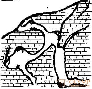
Figure 29 - Cave scheme in limestone.
Quicksand. In construction and mountain practice, sands are fine-grain and fine-grained, silty and heavy silty, aquifers, which, when opened by trenches or mine workings , float as a result of a pressure drop , i.e. they start moving, acquiring the properties of a viscous fluid. Bleeding can occur as a slowly thick layer, and quickly and even catastrophically quickly in the form of a breakthrough, as soon as they are opened and the more the soil is extracted, the greater the amount of it comes from the bottom and walls.
If the quicksands are set in motion, their stability is impaired, the stability of the enclosing rocks, slopes, slopes, landslides, underground workings, territories, and structures located or only constructed on them is impaired.
There are filtration filtration (false) and thixotropic (true) quicksand. Filtration fluids occur when the hydrodynamic regime changes, which usually occurs when water is pumped out of a pit or trench. When removing the dynamic mode, the water is clarified, the sands settle and even thicken. Thixotropic or true fluids in a fine fraction of particle size distribution contain colloids - particles with a size of less than 0.1 micron. Therefore, wobble shaken with water has a stable colloidal part and does not settle for many months. Their water retention capacity reaches 240%.
During construction in the areas of occurrence of floating rocks, special methods for preparing the foundation are used: freezing, fastening with sheet piling, draining with needle filters, etc.
4.8 Geological activity of lakes and swamps
Lakes. Reservoirs on the surface of continents that do not have communication with the seas and oceans are called lakes. They have a deep central area where coastal vegetation does not develop. The lakes are located at different altitudes (Dead Lake 392 meters, Lake Tibet +5000 meters). Dimensions - from tenths to tens of hundreds of kilometers (Lake Baikal - 31 thousand km2, Caspian lake - 395 thousand km2). The total area of lakes on Earth is approximately 2.7 million km2 (1.8% of land). The depth of the lakes is from tens of centimeters (Lake Elton - 80 cm) to several hundred meters (Lake Baikal - 1741 m). According to the regime, they are divided into flowing, feeding on rivers and diverting water to other lakes or rivers (Ladoga, Onega) and drainless, feeding on river flow, but only for evaporation (Caspian, Aral, Issyk Kul). The mode determines the mineralization of water: fresh, brackish and salty. The depressions occupied by the lakes have a diverse origin:
- tectonic - lakes in the depressions of tectonic origin (for example, Lake Baikal, Ladoga, Onega),
- erosion - the lake in the pits erosion;
- Karst - lakes in karst craters filled with water (for example, Lake Aya in Altai, etc.).
- dam and dam - lakes are formed as a result of landslides, mudflows, damming of rivers, dumping of dams, etc.
The geological work of the lakes is manifested in the abrasion (destruction) of the shores as a result of the activity of the waves catching up with the wind, the processing of detrital material and its accumulation in the form of lake alluvium. Beaches are formed along the coast, dunes are rolled up, shafts of material are formed when rivers flow into lakes. The dune part of the lakes is filled with clayey sediments, salts are deposited at the bottom of salt lakes. Small lakes gradually overgrown and can move into the swamp.
Tidal phenomena in lakes are small. Coastal abrasion is more intense under the influence of tectonic processes - rises or descents. When the water level in the lake changes dramatically on artificially created lakes (reservoirs), abrasion processes are most actively manifested in the early years of filling and partially exceed the planned coastline retreat tenfold (for example, Obskoe, Tsimlyanskoe, etc.). Measures to combat abrasion on the shores of lakes include fixing them, increasing natural beaches or their artificial dumping, sketching large w / w elements to reduce the force of the shock wave, etc.
Swamps. Bogs are an over-wetted land area with a layer of peat, covered with peculiar vegetation, which varies in different climatic zones.
Peat is called organic soil, formed as a result of natural dying and incomplete decomposition of plants in conditions of high humidity and with a lack of oxygen and a content of 50% (by weight) and more organic matter (GOST 25100-95).
Ground sand - clay and clay soil, containing in its composition in a dry sample from 10 to 50% (by weight) of peat (GOST 25-100-95).
A swamp is a plot with a peat capacity of more than 0.5 meters; with a smaller peat capacity, the plot is called marshy land. There are bogs and riding lowland. Upland bogs are located on flat watershed areas or at high terraces, they feed mainly on precipitation, peat is poor in minerals. Lowland swamps are located in river valleys, on the shores of lakes and seas, are formed as a result of overgrowing of lakes and oxbows, covered with grassy vegetation, have mineral nutrition, peat here is well decomposed (Figure 30).
Bog formations are classified as weak, strongly and unevenly compressible soils. Construction lead in difficult engineering and geological conditions. Mass civil and industrial construction in wetlands is usually carried out after they are drained, and sometimes after planning by dumping or reclamation of clay, sand, gravel-pebble or crushed stone.
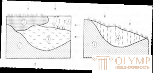
Figure 30- Types of wetlands:
a - lowland; b - riding; 1 - mineral bottom; 2 - peat;
3 - sludge; 4 - marshy ground; 5 - water (arrows show the power of the swamps with atmospheric water)
Bog formations are classified as weak, strongly and unevenly compressible soils. Construction lead in difficult engineering and geological conditions. Mass civil and industrial construction in wetlands is usually carried out after they are drained, and sometimes after planning by dumping or reclamation of clay, sand, gravel-pebble or crushed stone. Pipes through the swamp are laid in trenches with partial or complete reflowing.
The geotechnical assessment of the territory depends on the type of the swamp or marshy area. Special research methods are always required to determine the capacity of peat, the degree of its decomposition, the degree of ash content and aggressiveness of water. Without taking into account the peculiarities of construction, emergency situations are possible.
4.9 Glaciers
Glaciers are moving natural accumulations of ice of atmospheric origin on the surface, formed from solid precipitation above the snow boundary. The snow limit (line) is the height at which the annual arrival of solid precipitation is equal to their annual consumption, or during the year the snow falls as much as it melts. Below this limit, the accumulation of snow is impossible. Above the snow line the ice does not melt, but only accumulates. The height of the snow line and the intensity of glaciation depends on the geographical latitude, local climate, geography of the area and self-development of the glacier. In the south-east of Greenland, the height of the snow line drops to sea level, on Franz Josef Land - it is at an altitude of 50 to 300m, at the Polar Circle is already 1000m., In the Alps 2700-2800m., On the Himalayas 5500-6000m., In the mountains Equatorial Africa 5000-6000m.,
Ice thickness can be from 10-20m. up to several kilometers. So the Atlantic ice cover has a thickness of 4.3 km.
The water supply in the glaciers is estimated at 27 million km3 and is equal to the flow volume of all the Earth’s rivers over 700 years.
Glaciers are divided into three types:
Mountain glaciers are formed high in the mountains and are located either on the peaks or in the gorges, depressions, and various depressions. There are also glaciers in the Caucasus, the Urals, Altai, etc. Ice is formed by the recrystallization of snow, it has the ability to plastic flow, forming streams in the form of tongues.
Mountain glaciers are pendant and karst.
Lowland (continental) ice caps. In them the ice spreads from the ice divisions to the periphery. Such glaciers are characteristic of Greenland, Antarctica.
Ice shelves - in them the ice moves from the coast to the sea. When detached from the main body, icebergs float to the sea, which, getting into the warm waters, gradually melt.
Accumulation of snow in the mountains is accompanied by opposite processes - the unloading of snowy areas. It happens in two ways:
a) the fall of avalanches;
b) the conversion of snow into ice.
Avalanches - collapses of snow slipping from mountain slopes and dragging new snow masses on their way. Formed on slopes with a slope of more than 15 °. The avalanche impact power reaches 100t / m2.
If the whole relief is buried under the snow, the snow accumulates and turns into firn, and then into glacial ice. Firn is a mass consisting of large grains that are pressed into a crystalline mass of glacier ice.
Under pressure, the mass acquires plastic properties. The lower layers of ice, as it were, creep out from under the overlying firn and begin their movement from the feeding areas to the flow areas along depressions in the relief.
11 m3 snow firn 1 m3 lѐd.
In this case, the glacier does a great job of destroying, transferring and accumulating detrital material. With high ice thickness, enormous pressures are created on the subglacial bed and sides of the valley, and the glacier destroys the rocks, producing a glacial valley. The destructive work is greatly enhanced due to the fragments of rocks captured by glaciers during its movement in its bottom parts. Glaciers saturated with clastic material abrade, polish, plow the surface of the underlying and host solid rocks. On the surfaces are scratches, strokes, grooves (glacial scars). As a result, the smoothing of rocks occur peculiar forms (lamb foreheads). The combination of different forms of glacier impact forms "curly rocks".
As it moves, glaciers carry a huge amount of various detrital material - from fine particles to large boulders. All detrital material that enters the body of the glacier and is transferred and deposited by it is called a moraine (Figure 31) .
Moraines are different, some of them are in motion and move along with the body of the glacier, others are already postponed.
In addition to moving moraines secrete:
Lateral - in the form of elongated shafts or ridges along the glacial tongue.
The final - ridges of the moraine material at the edge of the melting glacier. They have an arched shape in plan and height from a few meters to 30-40m.
In the warm season, the ice melts more intensively and water flows bring material consisting of sand, silt and clay particles into the near-glacial lakes. In cold weather, flows weaken and bring only thin clay particles. As a result, lake-glacial (limnoglacial) band clays are formed with a very thin interbedding of sand and clay.
During the melting of the glacier, constant streams of water are formed, which erode the bottom and terminal moraines. Water picks up the material of eroded moraines, takes it out of the glacier and sets it aside in a certain sequence. Such glacial deposits are called fluvioglacial (Figure 32).
Figure 31 - Mountain glacier moraines:
a - the tongue of the glacier in cross section;
b - the same in terms of; 1 - bottom; 2 - internal;
3 - superficial; 4 - median; 5 - lateral; 6 - final
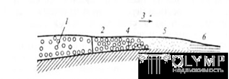
Figure 32 - Diagram of formation of fluvioglacial deposits:
1 - glacier; 2 — terminal moraine; 3 - stream of melt glacier water;
4 - 6 fluvioglacial deposits (large fragments, sand, clay)
Each type of these deposits has its own characteristics in the composition and conditions of occurrence. V. A. Priklonsky notes that all the moraine deposits due to the conditions of formation differ in heterogeneity both in thickness and extent, as well as in terms of engineering and geological characteristics. Clays of bottom moraines are over compacted and possess heaving properties, sand and gravel deposits of ozov and zandrov are successfully used as base soils if they take into account their specific features. Tape clays, when moistened, are referred to weak soils. Lateral and terminal moraines contain boulders, rock fragments and sandy-clay aggregate. All this complicates the engineering-geological assessment of moraine deposits during their use.
Что бы оставить комментарий войдите
Комментарии (0)