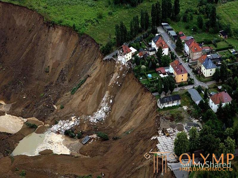
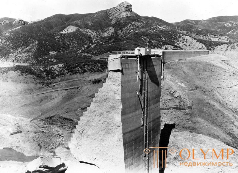
Destruction of the San Francis Dam (California, USA).
The dam is concrete, gravity, built from 1924 to 1926. The length of the dam along the ridge is 186 m. Height is 62 m. 0 drawing is curvilinear, the middle part is outlined with a radius of 130 m. The base width is 51 m. The reservoir capacity is 46 million m3. On the night of March 13, 1928, the dam collapsed / broke / and the water flow was 30 meters high, gushed down the valley, sweeping away everything in its path, causing enormous damage and taking many victims. Concrete blocks with a volume of up to 2500 m3 were attributed downstream to 800 m.
The dam foundation was composed of heterogeneous soils: shale on the left bank and in the center, and a red conglomerate on the right bank. Before the construction of the dam, geological engineering surveys in the required volume were not carried out. Thus, the strength properties of base soils, the possible change in these properties upon wetting, have not been studied.
What is the cause of the disaster? In the unanimous opinion of a number of commissions, a catastrophe occurred as a result of a change in the physical and mechanical properties of soils under the influence of water. These properties, as already noted, have not been previously studied.
The components of the conglomerate are clay and gypsum. Gypsum dissolved, clay softened, as a result, the strength of the soil, as shown by experiments, fell by 2-3 times.
The strength of shale ranged from 250 to 770 kg / cm2 and did not decrease under the influence of water. But the layered structure contributed to the sliding of the upper layers of the base downstream under the influence of water pressure.
Thus, as a result of the leaching of gypsum, filtration under the dam increased, which led to the formation of a large scour. The lower part of the dam collapsed into a ravine and carried away the upper part.
Into the formed precipice gushed, water, after which that part of the dam, which stood on the shale, was washed away.
For similar reasons, the accident at Austin Dam (Texas USA) in 1900, Sella Zereino (Italy) in 1955 and a number of other dams occurred when the strength and permeability of the foundations were not sufficiently studied during the survey.
The accident of a six-section 96-apartment brick residential building (Tula, Russia).
A typical five-storey building with longitudinal load-bearing walls, a basement and a store in the ground floor, built 90% up to the combined roof slabs collapsed in one of the sections to the height of all five floors (Fig. 2, a). Examination of the emergency building and the study of project documentation showed the following.
Precast reinforced concrete foundations laid 20 cm relative to the basement floor sank in the middle of the building along the external axis B up to 54 cm and shifted inside the basement up to 70 cm. There was no concrete preparation of the basement floor. The length of the building offset and precipitation of the foundations were unequal. These deformations led to the formation of soil swelling in the basement of shafts with a width of 1.2 ... 1.5 m and a height of 0.6 ... 1.0 m. On the middle axis B, the maximum settlement of the foundations was 54 cm with a shift towards the axis A up to 20 cm ( Fig. 2, b, c, d) . Shaft bulging located here on both sides of the basement wall. On axis A, sediment and basement displacements were not noted.
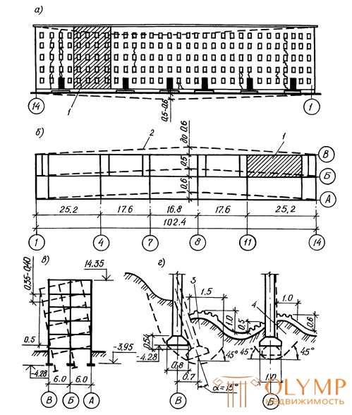
All dimensions are in meters.
Fig. 1.1. Emergency deformations of a residential building in Tula
a - the development of deformations in the facade wall; b - offset bearing walls in the plan; in-cross section of the building; g - the displacement of the foundations. 1 - the collapsed part; 2 - wall deflection;
3 - soil squeeze; 4 - deformation of the basement floor.
Due to the uneven deformation of the foundations under the longitudinal walls of the rigid box of the building turned in the transverse direction around the line passing along the axis of the foundations B. At the same time, the deviation of the upper part of the building wall from the basement line was 55 ... 60 cm. Large cracks were noted in the outer walls of the building. The main reason for the emergency deformations of the house was the incorrect assessment of the properties of the foundation soils by the surveyors. Using the values of the strength characteristics of the soil given in the SNiP for the design of foundations, the surveyors did not take into account that these tables apply only to quaternary deposits. At the base of the emergency house were clay soils of lower carboniferous deposits, which have a pronounced ability to reduce the strength and increase the deformation properties during exposure and wetting.
To the mistakes of surveyors and designers added errors during construction. Poor ground leveling around the building and the presence of a slope of the surface to it led to the penetration of rainwater into the basement through insufficiently compacted backfill and to over-wetting the base. The wall of the basement, in the absence of concrete preparation of the floor, began to work according to the scheme of a retaining wall with a slight deepening of the front face and an increased horizontal pressure of the wetted backfill soil on its rear face. The designers did not consider the possibility of changing the design scheme of the basement during construction, as required by the rules. Due to significant structural damage, the building had to be dismantled.
Along with an incorrect assessment of the properties of soils during exploration, it is not uncommon to find out that highly compressible layers of clay soils, and especially buried peat or peat soils, are undetected. Once at the base of buildings and structures, even outside the boundary of the compressible stratum, they can cause long-lasting and significant non-uniform precipitation.
In the practice of survey work for residential buildings of small and medium floors, the depth of exploration wells usually does not exceed 8 ... 10 m. This is considered sufficient to characterize the properties of soils and to carry out the necessary calculations of the foundation and foundations. However, this approach did not justify itself when linking buildings and structures in the so-called peated territories, which have plant residues in the composition of soil layers, including layers, layers or lenses of buried peat.
A year after the commissioning, the three-story brick building began to undergo uneven precipitations increasing in time. The study of technical documentation has shown that at the base of the building there is a thick mass of moraine, refractory, weakly compressible loams with a calculated resistance R = 0.2 MPa. The pressure at the base of its foundations did not exceed p = 0.18 MPa. The quality of the execution of the supra-foundation constructions did not cause any remarks. However, the growth of the sediment of the building continued, so it was decided to conduct additional engineering and geological studies. Having drilled a well with a depth of 15 m (previously, the depth of the wells did not exceed 8 m), they found the lens of a buried undecomposed peat with a thickness of 6 m or more, widely developed in plan. The presence of highly compressive soil, which was not detected at the survey stage, was the cause of the building deformations (Fig. 3).
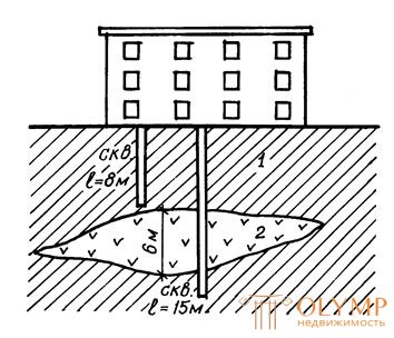
Fig. 1.2. Lens of compressible peat at the base of the building.
1 - moraine refractory loam; 2 - peat.
Что бы оставить комментарий войдите
Комментарии (0)