With all the diversity and individuality of the historical development of each city, their spatial development can be reduced to three main forms :
• consolidation of urban development, intensification of land use, active reconstruction (Figure 45).
Fig. 45 
• expanding the boundaries of the city and the development of new suburban areas (Fig. 46).
Fig. 46 
• “budding” from the city of new independent areas (satellite cities), geographically isolated from each other (Fig. 47).
Fig. 47 
The listed forms of spatial development often replace each other in the process of the evolution of the city.
In the framework of the cyclical paradigm, the city is considered as a self-organizing system. According to the theory of cyclical development, city-planning systems (major and largest cities, agglomerations) in the process of their evolution undergo alternating development cycles .
Centrifugal trends in the development of the city.
Accompanied by territorial growth, expansion of the city’s boundaries, development of new territories for construction (Fig. 48), as a result, leads to a lengthy communications, increased travel time, overloading engineering and transport infrastructure and inefficient transport operation in general.
Fig. 48 
This development cycle is completed when the urban planning system begins to work inefficiently. The territorial growth slows down or stops, the search for internal spatial resources and the reconstruction of the transport system begins, the town-planning activity shifts towards the center.
Centripetal trends in the development of the city.
Accompanied by compaction and reconstruction of the building (Fig. 49), the use of all spatial resources (increase in the number of floors, the development of previously undeveloped territories and underground space).
Fig. 49 
The buildup of the transport frame and the exhaustion of the available territorial resources leads to a new surge in territorial growth, a transition from centripetal to centrifugal tendencies. Urban planning activity is shifting to the periphery.
The change of development cycles of the urban planning system can be traced by the example of most of the largest cities in the world, including Novosibirsk, starting from the mid-twentieth century.
The territory of the city (fabric) is divided into structural planning units, the division is hierarchical in nature and contains several scale levels. This division is performed in order to optimize the processes of urban planning regulation (management, design, etc.).
• Planning areas .
The territories of the largest cities are divided into planning zones, the population of which may be more than 1 million people.
• Planning areas (in the general plan of the Novosibirsk sector) .
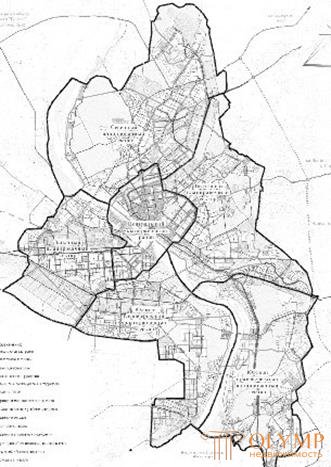
In large and largest cities, planning areas with a population of 100 to 500 thousand people are distinguished (Fig. 50).
In a large, medium or small city, planning areas may coincide with the main functional areas of the city (residential area, industrial area).
• Neighborhoods (neighborhoods).
Inter-trunk territory, population up to 20 thousand people, area up to 40 hectares.
The boundaries of the planning areas (zones) can serve as natural and (or) artificial barriers (river, relief drop, highway, railway, etc.).

Fig. 50. Novosibirsk, a map diagram of the structural parts of the city, materials of the general plan, SIASK, 2007
Что бы оставить комментарий войдите
Комментарии (0)