The main goal of engineering and geological prospecting is to obtain initial quantitative data for calculating the foundation and foundations of structures and for a quantitative forecast of changes in the geological environment during the construction and operation of structures, in particular the forecast:
- the occurrence and progress of engineering geological processes in the field of interaction of the structure with the geological environment;
- development of identified physical and geological processes;
- changes in the stress state of the soil mass, its temperature and water regimes.
Common tasks of engineering and geological exploration include the following:
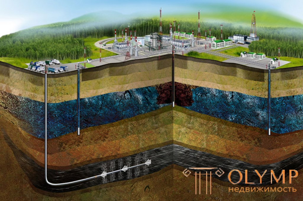
- the study of the geological profile of the grounds, the occurrence of rocks;
- determination of the physicomechanical properties of base soils, their water and temperature regimes;
- the study of hydrogeological conditions and geodynamic processes;
- the impact of the development of the territory on the change of engineering geological conditions;
- drawing up an engineering-geological model of the foundations or environment of the structures;
- the establishment of generalized values of indicators of physical and mechanical properties of soils in application to the selected engineering and geological elements.
Specific (particular) tasks of engineering and geological exploration are determined depending on the purpose of the designed structure, its design features and mode of operation, the complexity of the engineering and geological conditions of the construction site and the degree of their knowledge. It is important that reconnaissance be carried out on each object’s location.
The scope of work for the engineering-geological survey includes:
- geophysical work;
- stationary monitoring of the groundwater regime, the development of engineering and geological processes;
- mining and drilling;
- selection, installation and transportation of rock samples and water samples;
- experienced field work;
- determination of indicators of soil properties by laboratory methods;
- special types of research;
Engineering and geological studies can be performed with minimal cost and in a short time if modern equipment, advanced technology, and improved work organization are applied. These issues are resolved in the preparatory period and are reflected in the terms of reference, the work program and the project work.
Engineering and geological reconnaissance, survey or exploration are carried out on the basis of technical specifications and work programs. The task is prepared by the design organization, it contains a detailed description of the construction object, indicating the main design decisions, the presence of basements, specifies its placement in the plan and the expected load on the foundations and their type of impact (dynamic, static, etc.) the main tasks are formulated that must be solved in the process of engineering and geological surveys. Provides information about exploration work performed earlier, as well as special conditions related to the nature of production and building conditions. The task for exploration for individual structures is compiled from available materials of engineering geological survey, and for engineering geological survey based on available literature and stock materials , reconnaissance, filming and construction experience in the area. Approximate content of the technical specifications given in Appendix 2.
An important stage of the preparatory period is the preparation on the basis of the technical task of the survey program and first of all the determination of the composition and scope of work. This stage begins with the collection and processing and analysis of materials from surveys of past years.
Analysis of the natural conditions of available materials
A deep and comprehensive study of stock materials allows us to develop a working hypothesis about the engineering geological conditions of the area, substantiate the direction of the survey, determine approximately the amount and research methods needed to study this area as the site of future construction.
The main sources of information when collecting materials are:
- topographic maps of scales 1: 100,000, 1: 50,000, 1: 25,000; materials of state geological or hydrogeological surveys of 1: 500000 or 1: 200000 scale (for individual territories of 1: 50,000 scale and more);
- results of complex engineering and geological surveys for large industrial, civil, energy and other construction projects, as well as survey materials for small objects, including descriptions of individual workings, results of single or few analyzes to determine soil properties, etc .;
- the results of special case studies of individual elements of the geological environment inherent in a given area or a more extensive territory, characterized by a common geological history and features of the development of geological processes and phenomena. Such works may include the results of case studies on the study of landslides, loess, mudflows, geomorphological works on the study of relief-forming processes, the work of regional soil science, etc .;
- materials of methodical research to assess the possibility of using in this area any one or a set of methods for solving common complex or particular problems.
As experience shows, the best way to summarize materials from previous studies is to draw up a preliminary engineering-geological map (geo-conditions chart) and catalogs (card files) for actual material (mine workings, analysis results, etc.). In many cases, the studied materials can be used to construct geological and lithological sections and engineering-geological columns.
Survey program
The program consists of several parts.
The general part of the program includes:
brief information about the construction area, geographical location, road network, terrain, the possibility of movement of vehicles and mechanisms on the site of work;
brief information on the geological and geomorphological structure of the area, the presence and development of physical and geological phenomena, hydrogeological conditions;
information on previous survey data with the application of various extracts, copies of columns of workings, maps, etc .;
the possibility of power supply of the site for the production of drilling operations;
other information affecting the organization of field work.
In the section of the composition and scope of work indicated:
engineering and geological survey of the site;
the area and scale of geotechnical surveys divided by categories of complexity;
volumes and methods of mining and drilling works, indicating the structures of workings, methods of their penetration and liquidation; *
methods and volumes of engineering and geological testing, the procedure for packing and transporting samples and water samples;
device network of observation (hydrogeological) wells, methods and frequency of observations;
other work.
Experienced field work includes:
methods and volumes of experimental water pumping by hydrogeological wells, production of pilot fillings, etc .;
volumes and locations of points of dynamic and static sounding;
the volumes and locations of points for testing soils by experienced loads of dies and piles, impeller shear resistance, pressure tests, etc .;
methods, types and volumes of geophysical studies;
other experienced field work.
In the work section:
the sequence of various types of research is established;
specifies in accordance with what regulatory documents a particular type of work is carried out;
the procedure for adjusting, specifying, and changing the composition and scope of work is determined depending on the specific conditions and results of the excavation of the first workings, geophysical surveys, study of the outcrop, etc .;
provides for the safe conduct of work;
the necessary measures for the preservation of land and mineral resources allocated for construction are provided (backfilling of turfs, wells, tamponage, cementation, etc.);
establishes a methodology for laboratory determination of the composition and physico-mechanical properties of rocks;
determines the order of breakdown and binding of mining and drilling workings and test points, geophysical profiles, provides data on the creation of the planning and height reference network and the starting points of the planning and height reference;
the composition and volume of field documentation, duty plans and sections, the content of preliminary materials, the conditions of storage and reduction of core are established.
The final section of the program determines the composition and content of the technical report, graphic and textual applications, the scale of the planned material, sections, etc.
The work program together with the technical assignment and budget is agreed with the customer, approved by the leadership of the survey organization and is the main technical document for the entire period of engineering and geological work.
The preparatory period includes obtaining approvals and permits for the production of engineering and geological work in the territorial geological departments or for small-scale work in surveying individual construction projects, in construction and architecture in which the survey work will be carried out.
When large volumes of engineering and geological work with the use of diverse and complex technical means, especially in remote areas, a draft of the production of works. The project of production of works determines the founded organization of surveys. The project of work provides for the locations of the bases of the expedition, batches and detachments, the conditions of power supply, the production of combustible and lubricants. It is necessary to consider the issues of domestic and medical care for field workers in the work design.
The draft work provides the calculation of technical means for individual types and stages of research.
Что бы оставить комментарий войдите
Комментарии (0)